How Aiken County permitted development activities that led to road closures.
by Don Moniak January 11, 2024
On two occasions in the Fall of 2024 , the University Parkway (Hwy 118) portion of Aiken’s bypass was temporarily closed at its junction with Vaucluse Road. While the official reason for the closures provided by government officials was flooding, a better term would be “debris flow,” as heavy soil erosion caused by major rain events led to the road being covered with sandy sediments that posed an unacceptable risk to public safety.
The first incident occurred after approximately 8.0 inches of steady rain over a 24-hour period— Hurricane Helene and the “predecessor” rain event—fell from September 26-27. The second incident was on November 6th following close to five inches of rain in about a 12-hour period. According to a Department of Transportation report, the cause November 6th closure resulted from sediments that accompanied a stormwater detention pond failure that was under construction.
In both instances, the sandy debris originated from a housing construction site known as Highland Bluffs, where a subdivision of 110 single-family homes is under development, and 116 townhome-style apartments are scheduled for a second phase of development (Figure 1). The developer, Highland Bluff LLC, is operating on a relatively steep slope that was has been described by Aiken County Administrator Brian Sanders at a County Council meeting as “precarious.”
In April 2023, the Aiken County Planning Commission gave the developer preliminary plat approval for the single-family residences. The resolution any identified issues, including any that might be raised by the county’s engineering staff, was required before construction could begin. All of those contingencies were resolved by April 2024.
Construction began in May 2024. The heavily forested site was clearcut except for 10 to 15-foot forested buffers along the two roads bounding the site preparation work. Intensive grading ensued to prepare the site for high density housing.
According to County inspection reports*, problems quickly emerged in May and June that plagued the site all summer. The chronic issues included torn silt fences, an entrance that needed constant maintenance to prevent sediment from leaving the site, and soil erosion via strong winds resulting in sediments “leaving the disturbed area.” There were also “drink bottles/trash found in several areas” in May and “all over” the site in July.
In July, the county inspector reported (Figure 2) that lack of maintenance was allowing sediment to leave the site via swales (drainage ditches) in the site right of way entrances; and that the detention pond that was under construction was lacking riprap (stones placed on the shoreline to prevent erosion), a skimmer (to drain only the topmost, sediment-free layer of water), and slope stabilization. In addition, the catch basins were holding sediment, but sediment was also “leaving the site via a culvert.”
Figure 2: Portion of August 2024 county inspection report.
After a wet July that included at least one rain event of more than three inches, the inspector added that, “many slopes will need to be repaired. Issues along Vaucluse Road need to be addressed.”
By the end of a drier August, water erosion was again replaced by wind erosion that settled fine dust on neighboring properties, the culvert at the entrance was missing riprap, the detention pond still lacked erosion controls, and “both construction entrances (were) allowing sediment to leave site via swales in ROW.”
Figure 3: Before After Figure 4: September 28, 2024 road closureLooking east at Road Closure with sediment across road
Not a single local media source accurately cited the reason for the closure, leaving the misimpression that it was floodwaters that caused the closures, not a debris flow.
At Aiken City Council’s November 12th meeting, Aiken Public Safety Chief Charles Barranco confirmed the latter road closure stemmed from “debris from the property above the road.”
At County Council’s November 19th meeting, the issue was raised during the public comment period. County Administrator Brian Sanders also confirmed the closures stemmed from sediments originating from the Highland Bluffs construction site, and cited the detention pond construction as the primary source.
In response to subsequent questions raised by Council members PK Hightower and Kelly Mobley, Sanders also stated that “they have a right to develop their property,” and that “they are doing everything right.”
However, the County’s inspection records suggest that the County’s own guidelines legal guidelines for site preparation were arguably not met in this instance.
According to Section 19.5-23 of the County Code, these measures include the use of “temporary plant cover, mulching, and/or structures to control runoff…during the period of development or land use change,” disturbing the smallest area practical at any one time, retaining natural vegetation and saving topsoil, and provisions to “effectively accommodate the increased runoff caused by the changed soil and surface conditions; i.e. diversion ditches, grassed or surfaced water-ways and outlets, enlarged and protected drainage channels.
This is not the first new subdivision in North Aiken to suffer from excessive soil erosion during the site preparation phase that impacted neighbors and affected public safety. Similar dust storms originating from the Portrait Hills subdivision in early 2023–permitted by the City of Aiken—covered neighboring homes and businesses with a fine layer of gritty dust and sand and created visibility issues on Highway 19 North.
The lesson learned is that the promises made by local government to concerned neighbors regarding new developments should certainly be treated by concerned citizens with a dose of healthy skepticism.
Trolley Run Station in Northwest Aiken is one of the largest housing developments in Aiken County. At present, there are 1,066 housing units on the more than 1,500-acre site, with another 1,091 single family homes in the longer-term planning process (1).
One of the many subdivisions within Trolley Run is Wheaton Place, which is composed of 87 townhomes and was built between 2012 and 2016.
Within a few years, residents were experiencing problems from stormwater, including flooding of backyards and water intrusion; as well as and HVAC and plumbing defects. The problems were severe enough across the subdivision that the Lucey Law Firm of Mount Pleasant, South Carolina, was retained to seek remedy on the part of homeowners.
A class-action lawsuit (2) naming four defendants—the developer Invesco LLC, ATSCO, Inc, Wagaman’s HVAC Sales and Service, and Hardy Plumbing, was filed by Attorney Justin Lucey on November 11, 2020. In addition to the four initial defendants, “John Does #1-50” and “Jane Does #1-50” were listed to allow for additional defendants to be added to the suit. In total, an additional 32 defendants who had worked on aspects of the project were added to the Complaint; which was amended three times.
The order granting the class-action status was issued on February 2, 2022 (3). Eventually, 86 of the 87 eligible property owners signed up for the class action suit.
The allegations in the original Complaint were outlined as defective work that led to additional property damages:
“The residences contained latent building defects, which have resulted in cracking foundations, water intrusion, and MEP (mechanical, electrical, and plumbing) deficiencies. These latent defects, in combination with storms and other fortuitous events, and regular and repeated exposure to harmful elements, including but not limited to water intrusion and differential settlement, have caused consequential damages to non-defective portions of the Residences.”
A long series of Motions to Compel and Crossclaims have characterized the proceedings. In addition to the Plaintiff having to compel the production of records, especially from the developer Invesco, numerous Defendants filed Crossclaims and subsequent Motions to Compel against fellow Defendants.
Figures 1-4. (1) Heavy erosion on graded slope during construction (top); (2) Graded slope subject to heavy stormwater runoff into flat backyards and homes (middle); (3) Retaining wall that is gradually failing (lower right); (4) Aerial view of Wheaton Place townhomes subdivision (lower left). (Photos by Site Consultants, Inc.)
Three experts were retained to review the project and identify construction deficiencies and damages (Figures 1-3 and 5-8).
One expert, Thomas Sherod of Site Consultants, Inc., issued a report that described backyards as being “extremely flat;” which allowed for flooding following any significant rain event, and eventual water intrusion into homes. The retention walls were cited as being of poor quality, contributing to site erosion and compounding the flooding problems. Numerous defects of the site’s detention pond were also identified; with the pond described as a “hazardous catch basin” due to a lack of fencing and drainge deficiencies.
A second expert, Rhett Whitlock, identified a litany of issues, including non-weather resistant storage room and patio doors that were prematurely deteriorating, masonry stone veneer that was cracking, cracking slabs and foundations, inadequate waterproofing, finished flooring below grade, and “overall poor workmanship.”
A third expert, Warren Maddox, focused on HVAC issues, described code violations, including improperly installed ductwork, drain pans lacking draining capability, inadequate insulation, and adverse condensation issues.
As a result of the numerous defects, the average cost estimate for repairs was $125,000 per home—compare this estimate to the costs of the homes, which have sold for anywhere from $91,000 to $160,000 in the past decade. Only a few have been sold after 2020.
After three and a half years of litigation, defendants began to settle.
On May 4, 2024, the first partial settlement for $3,895,000 and involving fourteen defendants was ordered. After attorney fees and expenses, $2,202,040 was placed in an account for the homeowners.
On August 21, 2024, a Second Amended Motion for Partial Settlement was heard in the Second District Court of South Carolina. There were no objections from the twelve defendants in the second settlement, the Presiding Judge Kimpkins agreed to approve the settlement within a day. The total second partial settlement was for $1,799,750; in addition the developer, Invesco LLC, agreed to convey three of its remaining townhome properties that are currently under lease to the homeowner’s association.
In total, $5.7 million has been awarded to the Plaintiffs and $3.27 million is now in an account for homeowners.
Eleven defendants officially remain in the class-action suit, Unless another partial settlement is reached, the case will eventually go before a jury.
Figures 5-8: More alleged defects and damages. (Photos and original captions by Site Consultants, Inc.)
Footnotes:
(1) According to a recent development application to the County Planning Department for the Ashland at Trolley Run Station residential development:
“There are currently 523 single family homes, 288 apartments and 255 townhomes located in the development with one full access point on Vaucluse Road (Catenary Boulevard) and one full access point on Robert M. Bell Parkway (SC 118) (Trolley Run Boulevard) with an additional 612 single family homes and 246 townhomes constructed at Phase 1. At Phase 2 – Buildout, the site is planned to have a total of 2,226 single family homes, 288 apartments and 501 townhomes, an increase of 1,091 single family homes. One additional access points is planned on Vaucluse Road west of Catenary Boulevard, which is planned as part of the Buildout conditions.”
(2) The voluminous case file is available at sccourts.org. It is not a complete file; very few depositional or discovery documents are available.
(3) This was not the first class-action lawsuit involving townhomes in Aiken. In 2012 a class-action was granted for homes on Spencer Drive and surrounding neighborhoods. In 2014 another class-action was granted for more townhomes in the Eastgate area south of the former Aiken Mall. Lucey Law Firm also litigated those cases.
A public drop-in style meeting is scheduled for Monday, April 22 between 5:00-7:00 p.m. at the USCA Convocation Center to gather public comment and provide information to the public on an ongoing study to identify solutions to issues of traffic congestion, traffic safety, and projected growth along the 1.6-mile section of the Robert M. Bell Parkway/SC Highway 118 from USCA to Vaucluse Road. The public has been invited to email comments to Aiken County Planning and Development or to place comments in the comment box at the meeting. The letter below is being published here to raise awareness of this meeting and the issues that compel it. See more details on the meeting at bottom of this letter.
To Aiken County Planning and Development:
We moved to the Gregg Park neighborhood off Trolley Line Road in 2014. The close proximity to amenities like shopping, USCA, the YMCA and nearby Gregg Park Civic Center drew us to the area. We especially loved the relative quiet of the neighborhood and the setting — surrounded by pine woodlands and a couple miles removed from the bustle of traffic. This has changed a lot in the past 10 years, but most profoundly in the past several years, due in great part to a mix of unplanned and poorly planned growth in this area.
The collateral effects from this growth — issues of traffic congestion, traffic safety and erosion — have been driven down Trolley Line Road.
The Gregg Park neighborhood. Click to view full size.
The issues between SC Hwy 118 and Trolley Line Road are threefold. First, there is the increased traffic. Second, there is the lack of infrastructure to safely accommodate the increased traffic. Third are the erosion issues that have been created by clearing forests and leaving stormwater to do what it will. I will address these issues one at a time.
INCREASED TRAFFIC
The expanding Trolley Run Station subdivision has brought, and continues to bring, more residents to this area. Many of these residents use Trolley Line Rd as a shortcut/speedway to connect to the Aiken-Augusta/Jefferson Davis Hwy, or as a route to access the I-20 interstate or to access local schools, as this entire neighborhood, formerly zoned for Area 1, was rezoned for Area 3 schools in 2019.
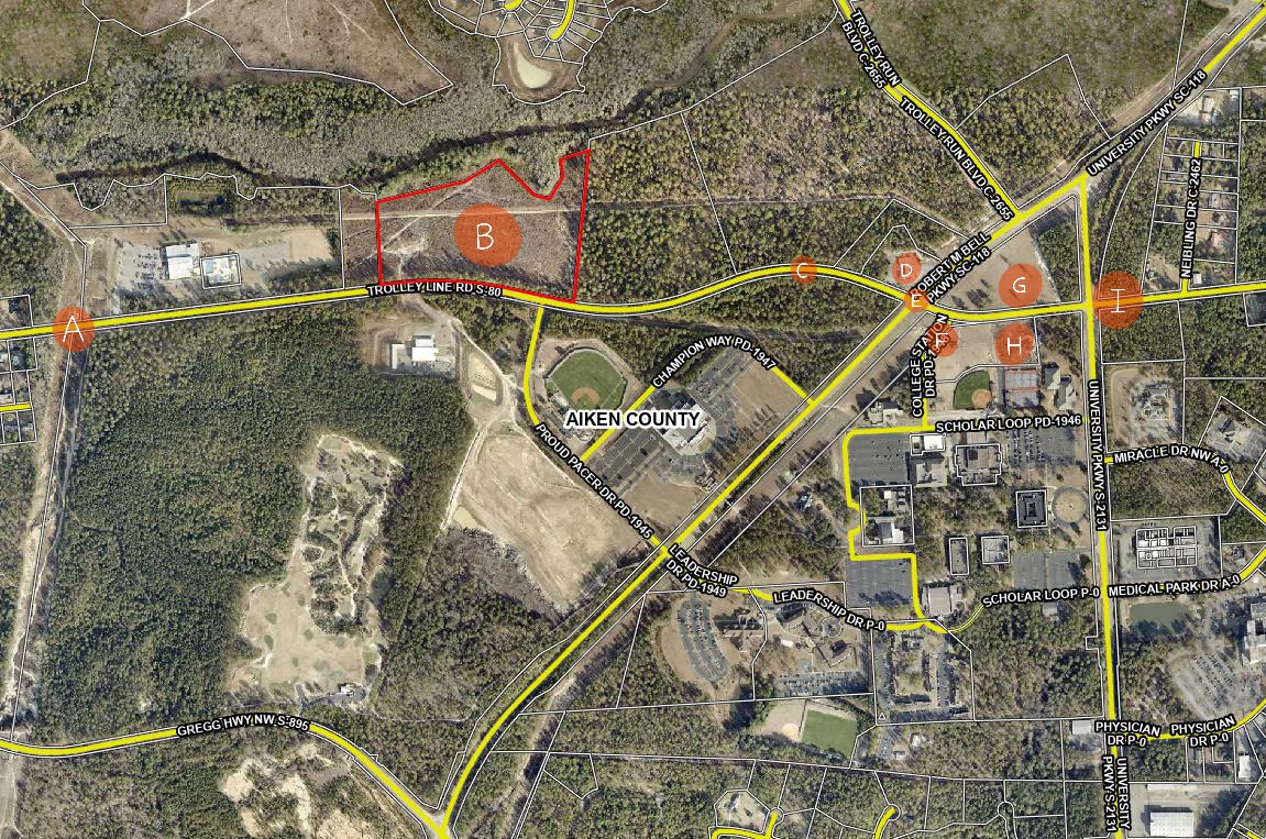
The upcoming expansion of 45 houses, (see marker B on map below) which will be sandwiched in the now-treeless acreage between Bridge Creek and Trolley Line Rd will send yet more traffic onto Trolley Line Rd.
Click image to view full size
Shortly to the east on on Trolley Line Road, next to USCA, are the Advanced Manufacturing Collaborative facility, (see marker H on map), which is currently under construction, and the adjacent, soon-to-be-constructed National Guard Cybersecurity Readiness Center and Dreamport (see marker G on map). Will these workers use the Trolley Line Rd shortcut to travel back and forth to 1-20, North Augusta, Augusta, Fort Eisenhower and SRS?
At present, drivers traveling west on Trolley Line, toward Graniteville, encounter a speed zone change from 45 to 35 mph as they enter the older, established Gregg Park neighborhood (see marker A on map). These signs are ignored, and with impunity, as there is no traffic-law enforcement. The heavy demand of hurried drivers has transformed this road into a high-speed thoroughfare. This was already a special problem area, with many neighbors posting signs imploring drivers, to no avail, to observe the posted speed limit.
The problem has grown exponentially worse over just the past few years. Drivers routinely exceed the speed at 50-70 mph, race up behind slower drivers, then cruise into the other lane, disregarding the double-yellow line and without regard for oncoming or incoming traffic. This has created dangerous conditions for the five streets and the 70-something driveways to the Gregg Park neighborhood homes (see top map) that front this stretch of Trolley Line Road.
Drivers entering Trolley Line from a street or driveway can get caught unaware by a driver speeding down the road at 70 mph who’s just decided to pass someone, threatening a head-on collision. Drivers attempting to make a turn off Trolley Line into a driveway or street can likewise be caught unaware of a kamikaze driver from behind, about to T-bone them in an attempt to pass. Averting rear-end and head-on collisions is a daily fact of life. This stretch of road has all the ingredients for a deadly crash.
Our teenage daughters drive this road daily to and from school and work. In the absence of traffic enforcement — and with laws prohibiting cameras to catch people who drive dangerously and in gross excess of posted limits — I wonder how we will regain safe access to the roads that lead to our home?
INFRASTRUCTURE
The infrastructure in this area has not grown to accommodate the volume of the increased traffic. The traffic-light intersection of Robert M. Bell Pkwy and Trolley Line Rd (see marker E on map) is especially hazardous for its non-existent rules.. Since there are no turn lanes, motorists are compelled to make their own rules, which results in games of chicken as no one can tell if the person opposing them is going straight or turning. Often, left turners just sit there stumped through the green light as to what they are supposed to do: who goes first?
Meanwhile traffic continues to back up to the east, as USCA students struggle to make the left turn onto Trolley Line Rd. from College Station Dr. (see marker F on map) — an intersection that would benefit from prohibiting left turns during posted hours — say, from 3:00-6:00 pm? After all, USCA has other exits into less trafficked areas on University Pkwy that would not add to rush hour congestion. As it stands now, the traffic at the light backs up during rush hour, with cars lined up from the light at Robert M. Bell Pky to University Parkway (see marker I on map). Heading east on Robert M. Bell Pky at rush hour, traffic may back up all the way to Proud Pacer Dr (at the Convocation Center). This makes a nightmare of our drive home. This intersection is dysfunctional and dangerous from every direction.
EROSION
The above issues are compounded by the further lack of planning for stormwater runoff. As the entire area continues to be clear cut tract-by-tract for development, little regard is being paid to how this concrete jungle will affect the low-lying sandy areas. Already you can see the effects, as vigorous rainstorms create extreme runoff that creates a stream of water and loose sand across Trolley Line Rd. (see marker C on map). The river of runoff sand is visible alongside the road in this area.
This runoff is also causing hazards at the entrance to the Circle K (see marker D on map) at the corner of Robert M Bell and Trolley Line Rd., where sinkholes deep enough to break an axle continually emerge, then get repaired, then re-emerge. Drivers turning into Circle K from Trolley Line are sometimes forced to come to a complete stop, which creates a bottleneck at this spot as they try to ease their way around these holes to avoid damaging their cars.
How much more runoff-absorbing plant-life will be removed? Seeing the lack of planning in the lands east of the Gregg Park neighborhood the 118 bypass and Trolley Line Rd , our family lives in fear of potential development in the wooded hillside between the Gregg Park neighborhood and Gregg Hwy (see map at top). Were similar deforestation to take place in this area, the runoff to Laurel Drive and the Gregg Park neighborhood would be catastrophic. We’ve already reaped a sneak preview of that from minor tree removal up in that hillside.
Larger overview of this area
In the 10 years we’ve lived in the Gregg Park the quality of life has markedly diminished as we’ve watched the woodlands around our neighborhood disappear. One by one, swaths of old-growth, longleaf habitat have been destroyed and paved over with expanding residental development, a golf course, and expansions to the USCA complex. The felling of trees has been followed by the burning of huge piles of refuse wood, leaving the air choked with thick smoke for weeks at a time. Future growth should take into account both soil erosion and air quality when making decision about clearing forests.
All of this is to say that future growth in this area does not take place in a vacuum up on SC Hwy 118. The surrounding roads and neighborhoods are a part of the equation and should be taken into account.
My hope is that, by shedding some light on the issues that have arisen in the development along the Robert M. Bell Parkway and Trolley Line Rd, measures will be taken to mitigate some of these issues and to not repeat these mistakes in future development in this area.
To reiterate:
There need to be turning lanes in on both sides of Trolley Line Rd at the Robert M Bell Pkwy.
The erosion and runoff at the Circle K and further down Trolley Line (see map point C) need to be addressed.
The speeding issues on Trolley Line Rd. need to be addressed, particularly in the Gregg Park neighborhood area where speed-limit signs are ignored and no-passing lines are disregarded. With the numerous driveways and streets entering the roadway, the recipe has been written for deadly accidents.
Aiken County Council recently approved spending more than a million dollars to address urgent wastewater and stormwater problems. The funds involve replacing “cheaper” equipment at the County’s wastewater plant, and repairing and cleaning a faulty, County-owned stormwater pond. Continued heavy development is expected to stress the wastewater treatment plant, and stormwater management programs.
by Don Moniak February 29, 2024
On Tuesday, February 20th, Aiken County Council held its fourth set of public meetings this calendar year.
The sessions began at 5 p.m with the three-person Development Committee convening to discuss and approve a series of resolutions for the “consent agenda.” (1) Two of the resolutions involved emergency expenditures to resolve serious problems with wastewater treatment and stormwater runoff. Three other resolutions were related to stormwater management, and one additional resolution pertained to the Horse Creek Wastewater Plant.
Cheap is Expensive
The first order of the Development Committee’s business was a resolution to spend $860,708 to purchase essential equipment for Aiken County’s Horse Creek Wastewater Plant. Due to recent sewage pump failures, the County is spending upwards of $200,000 per month for rental pumps and associated diesel costs. (see Meeting documents, pages 20-25).
The plant was designed and constructed in 1970’s, in the wake of the passage of the Federal Clean Water Act, and went online in 1979. Among its many accomplishments since then, it was credited with improving Horse Creek water quality enough to allow for fish populations to recover in what was a biologically sterile Langley Pond (2). (However, fish consumption advisories still remain in place.)
The plant traditionally used Patterson brand pumps in plant operations. This brand of pumps reportedly lasted more than three decades, with minimal problems. After the County switched to what County Administrator Brian Sanders termed a “cheaper grade of pump,” serious issues began within several years.
This time, the County wisely opted to skip the bidding process and go with a sole-source contract for higher quality, Patterson sewage pumps and replacement pump bowl assemblies.
The replacement process will take six months; the pumps themselves take four months to build. Until then, the County will keep spending hundreds of thousands on a bandaid solution—a case study in the oftentimes high costs of low cost.
The good news for the plant is that Council also approved a resolution to accept a $5 million grant for plant upgrades from the U.S. Environmental Protection Agency; illustrating again that in terms of outside financial aid and economic support, the federal government remains Aiken County’s best friend.
Figure 1. An example of Patterson Axial Flow Wastewater Pump. Aiken County has ordered a Patterson Axial Flow Pump Model 24×30 SAFV at a cost of $360,032 with a rating of 18,883 gallons per minute at 22.5 feet, which is smaller model than the one shown above. Fuller details of Patterson Pumps are available in this brochure.
Bad Pond
The second most expensive resolution passed during the meeting involved $247,000 (3) for emergency repairs and cleanup of a 2.6 acre stormwater pond property (Pages 31-36).
Aiken County owns 73 stormwater ponds, and most involve residential subdivisions. One of these ponds that is designed to control stormwater runoff from Gregs Mill at Horse Creek (Figure 2) is close to failure. The pond was purchased from Beazley Development in 2009 by Aiken County for $10; a “deed of dedication” that is one of many examples of a developer’s private liability being assumed by county taxpayers. (4)
The County’s current stormwater pond maintenance and repair contractor, Brown’s Grounds of North Augusta, described the problem, in part, as follows:
“The outfall pipe is sticking about 8 feet straight out of the dam slope suspended in the air due to severe erosion that has eaten a hole roughly 18 feet deep and 30 feet wide around this area. The end of the pipe is eroded and water is going through the pipe instead of the end of the pipe. A new Flare needs to be attached to help control the water flow. The erosion has caused a 20 foot section of the fence to be suspended in the air with a trough about 8 feet deep running under the fence into the adjacent property. The silt from all of this erosion has been pushed through the woods causing a trench about 4 feet wide and 100 feet long.”
The first estimate for repairs and cleanup, made on January 4, 2024, was $110,020. With the situation worsening after heavy rains, further threatening the Sunset Memorial Gardens cemetery below the pond, the estimate for the emergency work has rose to $247,000.
Figure 2. County-owned pond (center) near junction of Sudlow Lake Road and U.S. Highway 1. Cemetery is left, to the SW.
Pond Inspections.
The question arises: If five to ten ponds were to be damaged or fail during a major storm event—say 10 or more inches in 24-48 hours—how many millions of dollars would County taxpayers be on the hook for repair costs?
County officials are proposing a $2 million line item for unspecified “drainage projects” in the upcoming Capital Project Sales Tax referendum. During a recent discussion of this tax and spend proposal, County Administrator Brian Sanders stated that, “we know drainage issues are going to come up,” citing “too much development.”(5)
Monitoring and inspection of the ponds could help prevent future failures. Following the $247,000 stormwater pond repair resolution, Council approved another resolution to spend a mere $4,500 for Brown’s Grounds to inspect 30 county-owned ponds; 24 of which control stormwater from residential subdivisions.
“Stormwater Improvements”
Prior to the $247,000 pond repair and cleanup resolution, the Committee also approved a seemingly unrelated matter: acceptance of a “Deed of Dedication for an extension of Hartshorn Circle (C-3013), and Certain Stormwater Improvements in the Providence, Phase C2 Subdivision” of Trolley Run Station.(Figure 3)
While there were no financial costs yet associated with this resolution, it reflects why “too much development” will inevitably lead to more stormwater problems.
“Stormwater Improvements” is a bureaucratic misnomer; more proper terms for future deeds of dedication resolutions should be “stormwater controls” or “stormwater mitigation” projects.
Developments involving clearcutting of forestlands and stripping all the ground cover creates the necessity for stormwater control. There is rarely a need for “improvements” on undeveloped forestlands—the optimal watershed protection land condition.
Figure 3. Area of recent deed of dedication in Trolley Run Station; 2014 (bottom) vs. 2023 (top). The forested area shown in 2014 required no “stormwater improvements.” Note how the older portion of the massive subdivision (lower left) involved retention of a forested buffer.
Footnotes
(1) Committee meetings consist of three council members addressing, sometimes discussing, and then voting on resolutions that do not, by County law, require public hearings.
Instead, the resolutions are compiled into a “consent agenda” that Council votes upon as a whole during the regular meeting. The list of resolutions can include items as disparate as multimillion dollar property purchases, naming of private roads for the 911 system, ordering expensive equipment to meet immediate needs, and approving contract change orders. There is rarely a nay vote during deliberations.
“Discussion” is too strong a word to use for the February 20th meeting. The Development Committee spent 15 minutes reviewing 10 resolutions. There were no questions asked regarding the wastewater plant resolution, and few comments or questions regarding stormwater management issues.
(2) Conditions in Langley Pond following the beginning of Horse Creek Wastewater Plant operations were summed up in the abstract to the 1986 DHEC publication A Water Quality Assessment of Langley Pond; Aiken County, South Carolina. An Analysis of Sediment and Fish Tissue Data. (by Douglas Darr).
(3) Since Aiken County collects a $10 stormwater fee come property tax time, the expenditure amounts to 24,700 individual stormwater fee payments.
(4) Drainage easements are another County expense resulting from heavy development. Council also approved another resolution pertaining to stormwater control (Pages 41-45); an $83,000 purchase of a 1.65 acre drainage easement from Clifton Place Partner’s LLC—-one of several firms involved in new residential development along the Whiskey Road-Powderhouse Road connector project.
The easement purchase on undeveloped land between Powderhouse and Whiskey Roads was justified as part of the Whiskey Road Corridor Drainage Project, which is being funded in part from CPST funds approved in 2018.
(5) Statement made on Wednesday, February 28, 2024 during the Capital Project Sales Tax Study Committee meeting. Three Council members compose the committee reviewing the County’s proposed tax and spend proposals.
Other stories regarding water quality water use, stormwater, and wastewaster issues:
Earlier this week, there occurred an odd and interesting two days for City of Aiken land use planning, involving a city planning commissioner publicly speaking out against the city’s planning process; followed the next day by the commission’s near-rejection of a high-density housing development north of the City limits.
The 4-3 vote to forward a 338-unit housing development proposal to City Council for its consideration followed a confusing public hearing—confusion over what was promised and demanded by the Commission of the developer, and what was delivered to the people who requested concept plan changes. Specifically, a required traffic study has yet to be submitted to the South Carolina Department of Transportation (SCDOT), City Fire Marshall, or City Engineer for their review and approval. Adding to the confusion, the developer answered an expressed, though informal, request for reduced housing density by adding more homes to the proposed subdivision.
(Update, Feburary 16, 2024. On January 31, 2024, the City of Aiken issued a Request for a Statement of Qualifications “to solicit input from interested firms to determine if they have the experience and qualifications necessary to assist the City” in replacing the existing 25-year Zoning Ordinance).
By Don Moniak
February 16, 2024
One day after a City of Aiken Planning Commission member was granted, as a private citizen, a half-hour forum before City Council to express his discontent with the city’s land planning system and zoning laws, the Planning Commission (1) nearly rejected a proposed 338-unit, high-density housing development on forested lands currently located outside the city limits and surrounded by distinctly different, long-established neighborhoods.
The development in question has no proposed neighborhood name to date; i.e “Henderson Downs” or “Aiken Village.” It is only referred to as the “May Royal Drive development.”
The development area is situated on four separately owned parcels across ~81 acres, north of the City limits and bounded by the 70-year- old Crosland Park neighborhood, Osbon Drive, May Royal Drive, and U.S. Highway 1 North. (Figure 1)
Figure 1. Affected area. The planned subdivision is on the undeveloped lands in the center of the photo (Aiken County Public.Net land database). Click to enlarge.
The First Public Hearing
On November 14, 2023, a Planning Commission public hearing was held to review, discuss, and accept citizen comments for the proposed, yet-to-be-named neighborhood. During that meeting, not a single area resident spoke in favor of the project. More than a dozen spoke in opposition to some or all parts of the plans and raised serious questions about public safety, traffic, stormwater impacts, property values, and general quality of life issues such as noise and light pollution.
Concerns and questions were mostly expressed by long-time county residents and taxpayers who have resided on significantly larger, quiet, generally wooded, properties along Osbon Drive and May Royal Drive. Both areas are outside of the city limits. The development is going to negatively impact their quality of life and property values, although in ways that are too expensive and difficult to measure and monitor.
Traffic and housing density emerged as two of the dominant issues (2) that ultimately led the Commission to table the proposal. However, the development application was tabled strictly due to traffic issues, whereas only a general desire for a reduction in housing density was expressed by commissioners.
In terms of housing density, the consensus was clear that seven homes per acre was inconsistent with the surrounding neighborhoods, which currently ranges from 1-4 homes per acre. That consensus was best summarized by Commissioner Jason Rabun’s statement that “the concept plan is expected to change drastically.” However, no housing density conditions were added to the application that were binding on the developer.
In terms of traffic, there were serious questions about access onto Highway 1 North, entrances along narrow, winding Osbon Drive (Figure 3), and increased traffic volume on May Royal Drive.
The Commission did make one binding decision pertaining to traffic. A motion was approved to table the developer’s application until after a traffic study was submitted; after which the review process would return to the Planning Commission before being forwarded to City Council.
The process for the Motion to Table was riddled with confusion. The official motion within the meeting minutes only stated that the application would be tabled until a traffic study has been completed and has received input from the City Engineer and Fire Marshal. The preceding minutes suggest the intent was for DOT approval (Figure 2).
Figure 2: Draft meeting minutes for the 11/14/23 Public Hearing. The minutes were approved in December 2023. Minutes are the official written record that city attorneys would present to a court in the case of civil litigation. Click to enlarge.
The transcript (3) from the City’s archived live-stream only adds to the confusion. During the discussion, Commissioners expressed a desire for the following variety of review and approval conditions:
“Approved by DOT and reviewed by the city Fire Marshall for their input.”
“Review by the City Engineer.”
“Meet with the Fire Marshall.”
“Proper weigh-in from the City Engineer and the local authority.”
Not a single one of these specific sentiments was enshrined in the official motion, as defined in the Meeting Minutes. However, the last condition, “proper weigh-in from the City Engineer and the local authority,” appears to have preceded the actual motion, but was not listed in the official record. Input was not required from SC DOT and no approvals were necessary from DOT or other parties; only input.
Figure 3. Osbon Drive is a winding, narrow line lacking any center line. The traffic study lists it as having a capacity of 11,000 vehicle trips per day.
The Second Public Hearing.
Neither the desire for lower housing density, nor the demand for a reviewed and/or approved traffic impact study, were satisfied in the developer’s amended application:
The updated concept plan not only failed to reduce the housing density, the developer added five more units to the plan, raising the number of homes from 333 to 338.
No detailed, final traffic impact study was contained in the Commission’s document package. Instead, only a two-page summary of an undisclosed, initial traffic study, from the City’s Charleston-based traffic engineering consultant, was provided. That summary includes the information that DOT approval would be necessary at a later date. (Figure 4)
During the public comment period, a few concerned citizens identified the discrepancies.
In terms of the traffic study, Mayfield Drive resident Jennifer Roberts asked some pointed questions at the 24:40 mark of the meeting:
Ms. Roberts: “At the previous meeting it seemed that it was indicated that the South Carolina DOT traffic study would be done prior to this meeting. I am kind of confused by that. I do understand there’s a process after everyone else’s comments but just want to note that we are very opposed to it.” It was also brought up that they would also need Fire Marshall approval. Has there been (approval)?”
City Planning Director Marya Moultrie: As far as the concept plan, (the Fire Marshall) will do an initial analysis of the roadways. But ultimately when the developer goes to submit a civil plan (the Fire Marshall) will make sure they have enough fire hydrants and their turn radiuses are appropriate. It’s actually typically done at a later date and although they do kind do a cursory look at this they won’t truly dive into it until a little bit later in the process but they do absolutely have to approve the roadways, their turnarounds, their hydrant locations, all that must be approved.
Ms. Roberts: As neighbors will we be notified of any of these approvals?
Ms. Moultrie: That’s all part of the internal review that goes through all the different departments including our Fire Marshall and Public Safety.
After explaining that City Council consideration of the development would be in two weeks, Ms. Moultrie stated further that, the developer does “not have to share their engineer review from the Fire Marshall” during City Council’s review process.
In other words, what was perceived as promises were not delivered, and neighbors will not even be entitled to scrutinize the final review process until well after the development’s concept plan is approved by City Council.
Thus, due to the unclear, and improperly transcribed requirements for the traffic study on November 14th, what was conveyed as a requirement three months ago was not provided prior to Tuesday night’s meeting. The developer was allowed to submit a traffic study that was only summarized by the city’s contract traffic consultant, who somehow concluded that the impacts of thousands of new vehicle trips on nearby roads would be minimal.
The traffic study itself is unavailable, and yet to be formally reviewed or approved by most of the parties identified during the November 14th hearing; unlike some other development proposals—such as Parker’s Kitchen on Whiskey Road—where SC DOT approval was required before the proposal was forwarded to City Council. Instead, only a summary of a study was provided, and that initial, undisclosed study does not appear to have been “detailed.” (Figure 4)
Figure 4. Summary of the Traffic Study. Although the increase in “average daily trips” is three times the existing traffic on May Royal Drive, where most new residents will enter their neighborhood, the conclusion was “minimal impact on the adjacent road system.” Click to enlarge.
In terms of the housing density, Osbon Drive resident Gloria Brown inquired as to how more units could be added after the Commission had expected a “drastic change” to the plan.
Commissioners tended to agree with the sentiment, perhaps best summarized by Chairman Ryan Reynold’s statement that, “it leaves a bad taste when the Commission asks for fewer homes and you come back with more.”
Commissioner Clarkson cast one of three opposing votes. the fourth time since September he has objected to a high-density residential development. Mr. Clarkson also, for at least the third time in 18 months, expressed a desire for more restrictive “overlay districts” to prevent the creation of “more Whiskey Roads.”
Commissioner Charles Matthews also cast an opposing vote, based largely on the failure to look at the big traffic picture along Highway 1 North (Figure 5), citing another large housing development under construction just a mile to the south.
Commissioner Peter Messina was the third opposing vote. He took most exception to the housing density, outlining how hundreds of 0.14 acre lots are not consistent with surrounding 0.25 to 1.5 acre parcels, which violates the guidelines for Planned Residential zoning district.
Figure 5. Columbia Highway/Hwy 1 North during a slow time of day. The white truck is at the junction of May Royal Drive. The 338-unit subdivision will be situated on ~80 acres behind that truck. Area residents raised numerous concerns about their inability to turn left during peak hours; and when Grace kaolinite trucks are busy and during Emerson Plant shift changes. Several people have expressed the need for a traffic signal.
The “Joint” City Council/Planning Commission Work Session
(Update. The audio recording of the 2/12/2024 Work Session is available here.)
Commissioner Messina’s concerns were highly consistent with statements he made to City Council the day before the public hearing. He was the center of attention during City Council’s February 12, 2024, work session; in which the only agenda item was titled, “Planning Commission Update.”
The staff memorandum for the work session stated:
”Councilwoman Gregory requested that Planning Commissioner Pete Messina and other members of the Planning Commission discuss current Planning Commission procedures with City Council to provide an update and feedback.
Commissioner Messina and other members of the Planning Commission will be present to speak to Council this evening. We would like to schedule a joint work session of City Council and Planning Commission at a mutually agreed upon date.”
However, only Mr. Messina was allowed to speak at length before Council. After presenting himself as “a citizen of the town,” (4) and not as a Planning Commissioner, he began by stating:
“My main concern this evening is to talk about proper planning and planning in the right places, not haphazard planning.”
The issues he identified, which strongly reflect sentiments shared by many people across the community; but that are seldom clearly conveyed during the approval process for developments, included:
“There is too much haphazard development and growth,” and it is “too piecemeal.”
“In the town we worked in, we asked for a buildout analysis, look at the potential of the property, then hire a traffic study for the whole town, not piecemeal. Four proposals in a row with 90 (daily vehicle trips) per day does not require a traffic study but in total they should.”
Stormwater management only manages excess stormwater coming off the site, but too many retention ponds releasing at the same time can still cause problems.
Planned residential zones of five acres are too small, and allowable housing densities are often too high on areas that are smaller. There should be zoning for everything from 1/2 to 5 acres.
In terms of impervious surfaces, there are no standards. The only impermeable surface requirement is that 20-25 percent is open space.
There is a lack of information for concept plan reviews. Sometimes facades are not available to council; for example the Silver bluff shopping center. “Too many plans are on an 8.5 x 11 piece of paper that require a magnifying glass.”
If something is allowed that does not make sense, then the zoning would change; i.e change a zoning code so a car wash would be zoned out.
“Giving us something nice” leads to other nice buildings. If you start with a car wash the next-door development is not going to be nice. It is not something to be proud of.
The Comprehensive Plan covers growth from 30K to 50K. “You have to know how large a town you want to be. Ask the question: do we need another Citizens Park, another Odell Weeks,” to accomodate growth?
The county donut holes are a problem throughout the city.
Mr. Messina was allowed 30 minutes to speak as a private citizen, more than ten times longer than other private citizens are allowed to speak during regular Council meetings on nonagenda issues; six times longer than citizens are allowed to speak during public hearings.
During his speech to Council, the other six Planning Commissioner’s watched and listened.
After Mr. Messina was finished, Commissioner Clayton Clarkson walked to the podium and stated that, “We are 35 minutes into a meeting and only one commissioner has spoken.”(4)
Other Council members expressed discomfort with the way the work session was handled. Councilwoman Kay Brohl, who has also served on the Planning Commission, asked whether these issues had been discussed among the Commission. Councilman Ed Woltz, who once chaired the Commission, stated that it was the first work session he had attended in which Council had no materials to prepare for the meeting (6).
Two weeks ago, on January 31, 2024, the City of Aiken issued a Request for a Statement of Qualifications “to solicit input from interested firms to determine if they have the experience and qualifications necessary to assist the City” in crafting a new Zoning Ordinance. The RFQ was issued because the City is “considering a near-future Request for Proposal (RFP) for a new City of Aiken Zoning Ordinance to replace the current 25-year-old City of Aiken Zoning Ordinance.
|City Council has the option of ordering non-decisional Public Hearings on any significant issue (7). Council could request public hearings—one for each section of town—during which all affected citizens, both city and county residents, could raise concerns and ask questions about the land planning process, the existing zoning ordinance, and any future zoning ordinance—just as Council allowed one private citizen thirty minutes to do so. If such hearings were held, some Planning Commissioners like Peter Messina would find that there is widespread support for their advocacy of stricter growth standards.
Figure 6. Citizen concerns being raised during most recent City of Aiken Planning Commission meeting. From left to right: Commissioners Peter Messina, Charles Matthews, Steve Simmons, Chairman Ryan Reynolds, Planning Director Marya Moultrie, Vice-Chairman Jason Rabun, and Commissioners Sam Erb and Clayton Clarkson.
Footnotes
(1) The Planning Commission is an appointed body that makes recommendations to City Council; which is responsible for approving ordinances allowing for developments to occur. It does, however, establish its own by-laws.
(2) Stormwater was another serious concern, and one facing further scrutiny.
The developer agreed to mitigate light, noise, and aesthetic impacts by constructing a fence around the entire subdivision, and leave a 25-foot wooded buffer between the fence and neighboring properties.
(3) The transcript from the archived live-stream, edited for clarity (double wording and pauses removed), and focused only on the traffic impact study requirements, is as follows:
At 1:07:30
Commission Chairman: The (first) motion was to accept the application with the listed recommendations. My recommendation is to amend the motion, you would have to amend the motion to:
Commissioner: Yes, to require that the traffic impact study come back before us with the required changes that are going to be implemented based on the egress and ingress out of the development plus the buffer changes.”
Chair: Okay just just for clarity did you want to have the traffic study completed prior to going to city council?
Commissioner: That’s what I was asking.
Chair: So Commissioner Clarkson is amending his motion to include Commissioner Rabun’s condition that to include, so we can get it correct, that traffic study be submitted and approved by DOT and reviewed by the city Fire Marshall for their their input. (emphasis added)
(Commissioners agree)
At 1:10:49:
Chair: I think to make it cleaner (and not send to City Council), you table the applications and wait for the proper traffic study with review from the city engineer and then that allows them to come back without scrapping their application, is that correct? So with that knowledge now you can make another amendment?
Commissioner: I would add to my motion which is saying that we add the conditions that we have all talked about but just move to table it to allow them time to do the traffic study to meet with the fire marshal to make sure that doesn’t change this development drastically.
Chair: The motion was originally to accept this for or approve it or recommend for city council for approval based on the conditions, Commissioner Clarkson has amended. his motion now to table both these applications until further traffic study, with proper weigh-in from the city engineer and the local Authority so we can have a better understanding of the traffic situation because that appears to be one of the biggest issues in this area that we all agree upon. With that being said, do I have a Second to table?
The motion then passed.
(4) Planning Commissioner Peter Messina was the Town Engineer and Planner for Bernard Township, New Jersey for more than three decades. The Township is located 40 miles and 55 minutes west of Manhattan, New York.
According the U.S. Census Bureau, the township has a current population of nearly 28,000; a medium household income of $174,072; a poverty rate of 3.2 percent; a combined white and Asian-American population of 93 percent; and a median housing value of $744,000.
(5) Mr. Clarkson also disputed an assertion made by Councilwoman Gregory’s at the onset of the meeting, that the planning department had not properly notified other commissioners of the meeting.
(6) The situation also contrasted sharply with the January 22, 2024, Council Meeting. During that meeting, a Recreation Commission member rose during the “public comments on nonagenda items” portion of the meeting to relay that Commission’s vote to recommend a pause in the Smith-Hazel City Park redevelopment effort until there was a public hearing on what was actually being proposed. He was abruptly interrupted and cut off after speaking past the allotted three minutes.
(7) Sec. 2-69 of City Code allows for “Hearings by special committees. The city council may appoint a special committee to assist in or hold a public hearing for the council at any time upon any matter pending before it. Minutes or reports of hearings held by special committees shall be filed with the city clerk as public records.”
Instead of this option, “work sessions,” which are not defined in City Code nor described in the City’s outdated Handbook for Effective Boards, Commissions, and Committees, are routinely held; during which citizens are spectators who are denied input.