This Thursday, September 11th, the Aiken County Board of Appeals will hold a public hearing regarding an application for an exemption, or variance, to the legal requirement that driveways be 300 feet apart on a major thoroughfare—in this case Whiskey Road.
The applicant is the Drayton-Parker Company, from Savannah, Georgia, who plans to build a Parker’s Kitchen convenience store and gas station at the junction of Chukker Creek Road and Whiskey Road. In doing so, the company is proposing to build a driveway that is only 170 feet from the existing driveway at the South on Whiskey Event and Entertainment Venue and JC’s Seafood. It also proposes a deceleration lane on Whiskey Road that will begin only 30 feet from South on Whiskey’s driveway, creating a new safety concern on an already hazardous road.
by Don Moniak September 10, 2025
Three months ago, the Drayton-Parker Company, owner of the Parker’s Kitchen convenience store and gas station chain, bought a pair of properties totaling 3.67 acres at the junction of Whiskey and Chukker Creek Roads. The company did so with the intention of building its fourth establishment in Aiken County. The plan is for an eight-pump (16 filling stations) gas station and a 5,700 square foot convenience store similar to its existing locations in northwest Aiken and North Augusta.
This is the second location on Whiskey Road sought by Parker’s. The first was at the junction of Stratford Drive and Whiskey Road. That plan did not move forward following Aiken City Council’s decision in June 2023 to let the proposal die by not voting on the matter. After that, the company moved a half a mile south to its newly planned location.
The latest rendition of a Parker’s Kitchen on Whiskey Road appears to be a done deal. The appropriate zoning, Urban Development (UD), is already in place; meaning that the planned use does not have to endure a public hearing before the Planning Commission. Aiken City Council approved sewer and water services at its September 23, 2024 meeting. (Pages 171-185) At that meeting, there was some discussion of traffic concerns and close proximity to nearby residences, but the concerns paled compared to the failed effort to build at Whiskey and Stratford.
There is one stumbling block for this Parker’s on Whiskey Road, and that is access from Whiskey Road. At issue is Section 24-2.12.9.(1) of Aiken County Code, which states:
“No more than one driveway shall be allowed for every 300 feet of street frontage on major thoroughfares.”
Parker’s plan is for a driveway on Whiskey Road that will only be 170 feet from the nearest existing driveway.
That nearest existing driveway is owned by the South on Whiskey Event and Entertainment Venue at 3197 Whiskey Road, an activity center that has operated since 1998 and includes a miniature golf course, an event center, JC’s Seafood restaurant, and The Classic Cone ice cream stand.
Parker’s Kitchen proposes a deceleration lane that begins only 30 feet south of the JC Seafood’s driveway. While the deceleration lane is planned for the right of way and does not encroach directly upon South on Whiskey’s property, the move is nonetheless an infringement upon the businesses—it greatly reduces the buffer between the roadway and the miniature golf course, and it negatively impacts the ability of customers to safely turn either way onto Whiskey Road. (see Figures 1-3)
Figure 1: “X” is approximate location of the start of the deceleration lane. South on Whiskey is outlined in red, Drayton-Parker’s property is outlined in blue.
Figure 2: Approximate location of the deceleration lane. South on Whiskey’s driveway is in the foreground. Chukker Creek intersection is in the far background.
Figure 3: Parker’s Kitchen site plan. South on Whiskey is to the north/left. The deceleration lane is in the far upper left. On the upper right is a right hand turn lane that Drayton-Parker also proposes. The right-in, right-out driveway in the upper left is 300 feet from the Chukker Creek Road intersection, and 170 feet from the South on Whiskey driveway, which is not shown in the drawing.
The deceleration lane will lead to a right turn access into Parker’s Kitchen. The reason for that proposed access point is to keep a sufficient distance (300 feet) from the intersection of Chukker Creek Road. But in the process, Parker’s proposes its driveway be only 170 feet from the South on Whiskey entrance—-nearly half the required 300 feet between driveways required by the County regulations; and thus the need for a variance from the regulation.
1. “There must be extraordinary and exceptional conditions pertaining to the particular piece of property.”
Drayton-Parker argued, in their application, only that “sub-standard spacing exists,” a known condition when it applied for utilities services and when it bought the property. The circumstances are only exceptional because Parkers anticipates traffic levels that would dwarf another use; i.e. a medical office or a Dollar Store.
2. “These conditions do not generally apply to other property in the vicinity.”
Drayton-Parker has argued that “‘There are properties to the northwest that do not meet the 300’ driveway space.”
This is true for much of Whiskey Road, but not necessarily true for businesses that were established after the 2006-2007 time frame when the Highway Corridor Overlay (HCO) Ordinance was put into effect. The establishments that had to follow the driveway rules include Dollar General, Circle K, Mi Rancho, Lowe’s Foods, Fortress Storage, and Holiday Inn Express. In fact, Parker’s was prepared to adhere to this safety rule at its failed Stratford Drive location, and has adhered to the rule at every one of its other locations in Aiken County.
The driveway rule exists because too many driveways in close proximity were a contributing cause, if not a root cause, for the unsafe and congested conditions that characterized Whiskey Road twenty years ago. The safety regulation was put into place to avoid exacerbating that aspect of the problem.
3. Because of these conditions, the application of the rule in question “would effectively prohibit or unreasonably restrict the utilization of the property.”
Drayton-Parker argued that “The application of the ordinance to this property would prohibit access on S.C. Hwy 19(Whiskey Road).” This appears to be the only criteria that the application meets in a clearcut manner.
4. The authorization of a variance will not be of substantial detriment to adjacent property or to the public good, and the character of the district will not be harmed by the granting of the variance.
Drayton-Parker claimed that a Traffic Impact Analysis showed that the project will “not have a negative impact on the adjacent properties.”
John Hyder, the owner of South on Whiskey and JC’s, disagrees, and is challenging the variance. He believes the deceleration lane is both dangerously located too close to his driveway, and that the increased difficulty of right hand turns from his driveway will deter business.
As he puts it:
“I am not against growth and development. I feel the codes and regulations were put in place to guide development in a safe and consistent manner. I just want developers to follow these rules.”
It appears that Drayton-Parker Company bought its property with the knowledge that it had to obtain an exemption to a traffic safety regulation in order to have access from Whiskey Road.
There is little question that its plans will have a detrimental impact on the adjacent business, South on Whiskey’s operations; the question is whether that detriment will be “substantial” and whether Drayton-Parker is deserving of an exemption that has not been granted to other entities on the Whiskey Road Highway Overlay.
(The Board of Appeals meeting is at 6:30 p.m. in the Sandlapper Room on the first floor of the County Administration Building at 1930 University Parkway. The application for the variance can be found on pages 38 to 46 in the agenda documents. )
Close to 1500 new homes could be built in the near future along State Highway 19 North (Edgefield Highway) between the Aiken bypass and Interstate 20’s Exit 18. Since 2021, Aiken City Council has approved development plans for two subdivisions within city limits that will involve more than 500 new homes. Council has also approved water and sewer services for more than nine hundred new homes outside of the city limits, most recently approving services for 705 new homes in a 212-acre subdivision known as Bridge Creek. Meanwhile, no safety improvements are planned for the narrow and increasingly congested road.
by Don Moniak March 10, 2025
In 2014, the City of Aiken, Aiken County, and SC Department of Transportation (DOT) held public meetings to gauge community sentiments over safety and future development along Highway 19 North, also known as Edgefield Highway. During the meetings, a number of major safety issues were identified by area residents (Figure 1).
Since 2014, the only progress, safety-wise, that has occurred are two new left-hand turn lanes and one new right-hand turn lane. Only one of these, a northbound left-hand turn at Good Spring Road, was constructed to improve existing traffic flow. The other two turn lanes were mandated by the County and DOT as mitigation for the traffic increase from a new subdivision called River Crossing.
Meanwhile, the bulk of the safety and congestion issues identified in 2014 have worsened with increased traffic; which SC DOT estimates as being 11,800 average vehicle trips per day. According to the latest reports from the Augusta Regional Transportation System (ARTS), no improvements are currently planned along this stretch of road.
Figure 1: Safety issues identified along Hwy 19N in 2014.
The five-mile stretch of State Highway 19 North (also known as Edgefield Highway) between I-20’s Exit 18 and the Aiken bypass (Hwy 118) is arguably one of the most dangerous major roads, if not the most dangerous, in Aiken County.
A two-lane thoroughfare for its entire length—except for a 0.2-mile stretch of four-lane through the small commercial district south side of Exit 18–the road meanders through three long curves, a few straightaways, and one traffic signal. The near-absence of wide shoulders results in the Highway Patrol and the Sheriff’s Office generally taking a hands-off approach to enforcing traffic laws.
Turn lanes are absent at the the busiest intersection at Reynolds Pond Road, as well as at every other of a half-dozen junctions; all of which commonly lead to traffic backups.
The road passes through a steady mix of residential, commercial, institutional, and light industrial land uses; including about fifty homes, three churches, one restaurant, one busy gas station/convenience store, a Dollar General, a barber shop and seasonal fruit stand, two beauty salons, a daycare center, two used car lots, three auto repair shops, a metals recycling center, two construction offices, two self-storage enterprises, a private nightclub, a screened road rubble storage property, a major electric substation, a dusty, empty lot that doubles as a flea market, and a well-screened, 30-acre automotive junk yard.
Nearly every homeowner and business on the west side of the road has mailboxes on the east side of the road; residents must navigate through fast and heavy traffic just to retrieve their mail.
The presence of so much private property along the route complicates the potential for any proposed road widening or other access enhancements. Any plan for improvements would face the daunting task of a heavy dosage of eminent domain. Simply put, unlike University Parkway or Hwy 78, widening of Edgefield Highway is almost an impractical option.
In spite of these limitations, the City of Aiken began moving forward, beginning in 2019, with utility upgrades, particularly sewer services, in the Exits 18 and 22 areas. The intent was to service and attract new commercial and residential development—including an effort to attract one major new business around Exit 18, widely rumored to be a Buc-cee’s travel plaza.
But whereas a modern, wide, four-lane road (Highway 1N) with a continuous middle turn lane for a median (1) leads to Exit 22, the road leading to Exit 18 (Hwy 19N) remains a winding two-lane with a meager scattering of turn lanes.
Despite the lack of safety improvements, three new subdivisions along the route have been approved since 2021, and a larger fourth one is under proposal. Two of the subdivisions, 150-home Portrait Hills and 330-home Rutland Place, are in the City of Aiken; while the other two, the 200-home River Crossing and the proposed 705-home Bridge Creek, are on unincorporated county lands, but subject to future annexation.
The proposed 705-home Bridge Creek subdivision (Figures 3 and 4 below), which is located on 214 acres along Highway 19 and between Croft Mill and Mayfield Roads, has the potential to add the most new congestion because of its size and the fact that the only proposed access is along Hwy 19. (As a point of reference, the massive Trolley Run Station subdivision currently has approximately 1,066 housing units).
Current state of property
Both access points are proposed at locations along long curves (Figures 4 and 5 below) The developer also plans to intrude upon residents who reside on Alan Drive, a cul-de-sac neighborhood also known as Bedford Park.
Looking north on Hwy 19. Looking south on Hwy 19, both access points are in view
The Aiken City Council, with minimal discussion, approved water and sewer service for Bridge Creek on January 27, 2025. The ultimate decision on access and project size will be determined by Aiken County’s Planning Commission or by Aiken County Council. To date, no application has been submitted to the County planning department.
Footnotes:
(1). There are a few dedicated turn lanes, but most of the Hwy 1N median is designed for either left or right-hand turns.
(2) Developer’s description of the proposed Bridge Creek subdivision. (click to enlarge).
Parker’s Kitchen’s Simplistic, Single-Variable Approach to Residential Neighborhood Concerns.
by Don Moniak September 15, 2024
The Savannah-based Parker’s Kitchen gas station and convenience store chain is making a big splash in the Augusta-Aiken market. The company’s expansion into the area involves at least ten new stores—five on the Augusta side of the river, five on the Aiken County side.
The design of Parker’s gas stations and convenient stores are typical of our modern landscapes. The company’s standard store has eight fueling stations and ~5,000 square-foot, 24-hour convenient stores that feature fried chicken and hot-bar breakfasts and lunches—similar in size and amenities to those found at new or updated Circle K’s, Sprint, Pilot, and QT stations.
In Aiken County, the company has obtained approval from local governments to open four stores—two in North Augusta and two in Aiken (Figure 1). All four stores share the trait of being located in existing, well-established commercial and/or industrial districts relatively distant—500 feet or more— from residential neighborhoods. These Parker’s locations have been established without any citizen outcry.
(Figure 1 below: The four approved Parker’s Kitchen locations in Aiken County. The Richland Avenue store has opened for business, the Edgefield Road location in North Augusta is in the site preparation process, the Hwy 1/I-520 store is preparing to open, and the East Pine log location remains in the pre-development stage. Click to enlarge.)
Richland Avenue, WestEdgefield Road/Ascuaga Lake RdHwy 1/I-520East Pine Log Road/Hwy 78
Parker’s Kitchen has only encountered organized citizen opposition at sites that were too close for comfort for residents of older, well-established neighborhoods. In the past year, both Columbia County and the City of Aiken rejected proposed Parker’s locations on South Belair Road and Whiskey Road, respectively, due largely to formidable neighborhood opposition.
In June 2024, the company failed in its attempt to establish its presence in South Aiken at the busy and dangerous intersection of Whiskey Road, Powderhouse Road, and Stratford Drive. There, six months of sustained opposition centered on a myriad of concerns that included noise and light pollution, exposure to benzene and other chemical hazards, Whiskey Road’s chronic traffic congestion at an already dangerous intersection, the risks of fuel truck accidents that could block the only access to two large neighborhoods, incidences of crime at 24-hour convenient stores, a complex zoning issue, and proximity to nearby homes—in this case ~300 feet.
After losing the Stratford and Whiskey Road fight to a well informed and organized community that already had three years of experience fighting city hall, Parker’s sought a new location on Whiskey Road.
This time around, the site is a half-mile to the south, at the corner of Chukker Creek and Whiskey Roads (1). Although some of the same issues as the Stratford location remain, this latest effort is very likely to gain local governmental approvals.
Unlike the abandoned Stratford and Whiskey location, the intersection of Chukker Creek and Whiskey Roads has the advantages being at a less complicated and safer intersection, and being in the unincorporated portion of the county within a zoning district—Urban Development (UD)—that has minimal restrictions on commercial and light industrial developments.
The City of Aiken’s only role is to approve a simple water and sewer service request—which are rarely denied—and not a zoning change and development concept plan. Another advantage for such developments is that, except for traffic issues, City Council approval does not directly impact any city voters.
At the same time, several issues that drew opposition to the Stratford and Whiskey proposal will remain. Most notable is the increased traffic at a busy intersection which, in this case, is the only routine access point to Whiskey Road from Chukker Creek Elementary School— a concern already raised by a nearby resident during the City’s Planning Commission meeting on September 10th (15:40 mark).
The proximity to homes (Figure 2) also remains an issue. The nearest neighbor, whose home is only 150 feet away from the site boundary (Figure 3) wrote a letter of concern (page 46 ) to the Planning Department and Commission.
(Figure 2, below. Parker’s Kitchen proposed locations near existing residential neighborhoods. Click to enlarge).
Chukker Creek/WWhiStratford/Powderhouse/Whiskey RoadFigure 3, above. Comments by an Aiken County resident to City of Aiken Planning Department. The resident’s property is adjacent to the proposed Parker’s Kitchen. The only separation will be a ten-foot buffer. The developer has agreed to a (six to eight foot) privacy fence. Click to enlarge. See Page 41 for conceptual layout of the proposed gas station and convenient store. Click to enlarge.
Parker’s Simplistic Answer Regarding Life Near A Major Gas Station.
In April of 2023, Parker’s responded to the issue of the proximity of homes to gas stations by submitting a simplistic, single-variable analysis to Aiken City Council (2).
The motivation behind the company’s submission was a singular public comment:
“A comment has been mentioned that there are no convenience stores located near residential properties in Aiken. The following is some examples of several that are. There are pictures of the measurements from the Aiken County GPS maps included.”
The report that followed cited five gas stations in and around the city that are closer than 300 feet to at least one neighboring residential property. Parker’s looked only at one variable—the distance between existing gas stations and the nearest home; but not necessarily to the nearest residential neighborhood.
The company’s submission to Council ignored the numerous variables directly related to residential proximity to gas stations that were repeatedly raised by concerned citizens; including access to and from neighborhoods, operating hours, impacts on property values, the prevalence of crime, routine exposure to chemicals, and the consequences of a fuel truck accident during deliveries.
The company’s implication was that if people live near another gas station, then it must be acceptable to site a new gas station near where people live.
A second set of variables ignored in the “analysis” were facility size and age— the five comparison fueling sites are one-eighth to one-half the size of the standard Parker’s Kitchen eight-pump gas stations and 5,000 square-foot stores (Figure 4).
Four of the five comparison gas stations were built in the 20th century before the City’s current zoning ordinance was in effect. With few exceptions, current nearby residents chose to live near a gas station; whereas Parker’s was, and is, choosing to establish itself near residents who did not op to live near a major gas station and 24-hour convenience store.
Parker’s Comparison Gas Stations
The first Parker’s Kitchen to locate in Aiken County is at the intersection of Richland Avenue and the Hwy 118 bypass, site of the former Dick Smith auto dealership. The development was welcomed by, and faced zero opposition from, a community accustomed to viewing an increasingly blighted property at the western gateway into Aiken.
The station is typical of modern Parker’s facilities—eight fuel stations and a 5,600 square-foot convenience store and restaurant on more than three acres. (Figure 4)
Figure 4: The new Parker’s Kitchen at West Richland Avenue/Jefferson Davis Hwy and the Hwy 118 bypass/Hitchcock Parkway on the edge of the city limits. The business replaced a vacant, blighted auto dealership. Figure 5: The two-pump, diesel-free, Shell station and convenience store at Huntsman Drive and Hitchcock Parkway. (Google Earth photo)
The characteristics of this typical Parker’s facility contrasts sharply with the five gas stations company representatives chose to prove that some people do live close to gas stations.
The first example (Figure 5, above) was the “Huntsman Shell on the Hitchcock Parkway (which) is contiguous to the residence at 70 Deerwood Dr.”
The Huntsman Shell station at 1830 Huntsman Drive was constructed in 1986, has two fuel pumps ( but no diesel), and is located on 0.42 acres—but within a larger shopping plaza of 1.5 acres. The convenience store itself is only 2,000 square feet.
Figure 6. Sprint on East Pine Log. Note the tree buffer in the rear. The only access points are on East Pine Log Road itself. (Google Earth photo)
The second example (Figure 6, above) was the newer “Sprint store on (912) East Pine Log Rd….contiguous to two residences in the Gatewood neighborhood.”
Built in 2008, it is the only one of the five comparison facilities that was subject to the existing Zoning Ordinance.
The size is comparable: six pumps spread across three fueling stations; and a 3,500 square-foot convenient store.
But the business only occupies an acre of land, there is no vehicle access to the adjacent Gatewood community, and a sixty-foot forested buffer separates it from the nearest neighbor.
In comparison, Parker’s proposal at the Chukker Creek location is a ten-foot buffer that may or may not involve a vegetative screen.
Figure 7. The Circle K at Banks Mill and East Pine Log. (Photo courtesy of Aiken County land database.) The house in the background is the City’s Parks and Recreation Headquarters. (Photo courtesy of Aiken County Assessor’s Office).
The third example (Figure 7, above) was a “Circle K store located only 150′ from the ‘swimming pool’ located at 332 Woodbridge Road.”
The facility is located on 1.72 acres at 1011 East Pine Log Road, at the junction of Banks Mill and East Pine Log Road. It has four fueling islands and four pumps, no access to nearby neighborhoods, and was built in 1996. The convenience store is 3,345 square feet.
There is no direct access to the nearby Gatewood Community, and a 0.72 acre forested parcel with a detention pond sits between the Circle K and the “swimming pool” property, providing a 110 foot buffer.
Figure 8. Circle K on Hitchcock Parkway. (Google Earth photo)
The fourth example (Figure 8, above) was the “Circle K store located at 315 Hitchcock Parkway…contiguous to the residence at 70 Augusta Rd.”
This gas station is not even within the city of Aiken and there is only the one resident within 500 feet.
Located on 1.6 acres, the facility has only two fueling islands with a total of four pumps, no access to and from any nearby neighborhoods, and features a convenience store of only 1815 square feet.
Figures 9 and 10. The City of Aiken’s small fueling station at the Engineering and Utilities Department on Dupont Street; within an open and and parklike landscape. (Photos by Don Moniak)
The final, and most comical, example (above) was “The City of Aiken’s gas & diesel pumps (that) are only 120′ from the residence at 915 Jones Dr. and also only 145′ from the residence at 916 Jones St.”
The city’s fueling station at 240 DuPont Drive has two fuel pumps on a single fuel station island. The property was developed in 1974 for the engineering and utilities department.
It is within a shaded, scenic, well-managed landscape. There are two lights above the pumps—not much brighter than a street light. There is no convenient store associated with the fuel pumps, and the fueling station is generally only used during daytime hours.
Summary
As Parker’s Kitchen has grown throughout this area, substantial opposition has emerged to its plans only when the company has tried to shoehorn a large modern gas station and convenience store close to established neighborhoods.
The company’s analysis in 2023 of older gas stations that are within 300 feet of homes offered only that single variable—distance to a home—while ignoring the justifications for citizen concerns.
Essentially, unless a neighbor can prove an older, smaller gas station has made them sick or damaged their property values—both very hard cases to prove even when true—then Parkers views as appropriate the siting of substantially larger and louder gas stations/convenience stores near other neighborhoods.
Figure 11. The Racer’s gas station and convenience store at the junction of Vaucluse Road, Trolley Line Road, Hampton Avenue, and Shore Drive (Six Points). It too is within a few hundred feet of several nearby residents, but is a fraction of the size of a Parker’s Kitchen. In the early 2000’s it was plagued by robberies until it ended 24-hour service.
Footnotes
(1) The two properties are:
A 1.8-acre forested parcel that is zoned Urban Development by Aiken County. The property is classed as Agricultural use, resulting in a market land value of only $420 and tax assessment of only $20. This is despite the fact that agricultural usage requires a minimal of five acres.
A 2.0-acre forested parcel that is zoned Urban Development and classed as Commercial use by the County Assessor’s Office. The land value is listed as $350,000.
It was then only referenced as being the handiwork of Parker’s Kitchen during the first, and only Public Hearing that evening.
The submittal reappeared in the June 12, 2023, informational packet, that time with Parker’s identified as the author. It was at the June 12th meeting that the concept plan Ordinance “died” for lack of a Second to a Motion to approve.
Past Stories Regarding the Parker’s Kitchen at Stratford and Whiskey, and Gas Stations in General
A public drop-in style meeting is scheduled for Monday, April 22 between 5:00-7:00 p.m. at the USCA Convocation Center to gather public comment and provide information to the public on an ongoing study to identify solutions to issues of traffic congestion, traffic safety, and projected growth along the 1.6-mile section of the Robert M. Bell Parkway/SC Highway 118 from USCA to Vaucluse Road. The public has been invited to email comments to Aiken County Planning and Development or to place comments in the comment box at the meeting. The letter below is being published here to raise awareness of this meeting and the issues that compel it. See more details on the meeting at bottom of this letter.
To Aiken County Planning and Development:
We moved to the Gregg Park neighborhood off Trolley Line Road in 2014. The close proximity to amenities like shopping, USCA, the YMCA and nearby Gregg Park Civic Center drew us to the area. We especially loved the relative quiet of the neighborhood and the setting — surrounded by pine woodlands and a couple miles removed from the bustle of traffic. This has changed a lot in the past 10 years, but most profoundly in the past several years, due in great part to a mix of unplanned and poorly planned growth in this area.
The collateral effects from this growth — issues of traffic congestion, traffic safety and erosion — have been driven down Trolley Line Road.
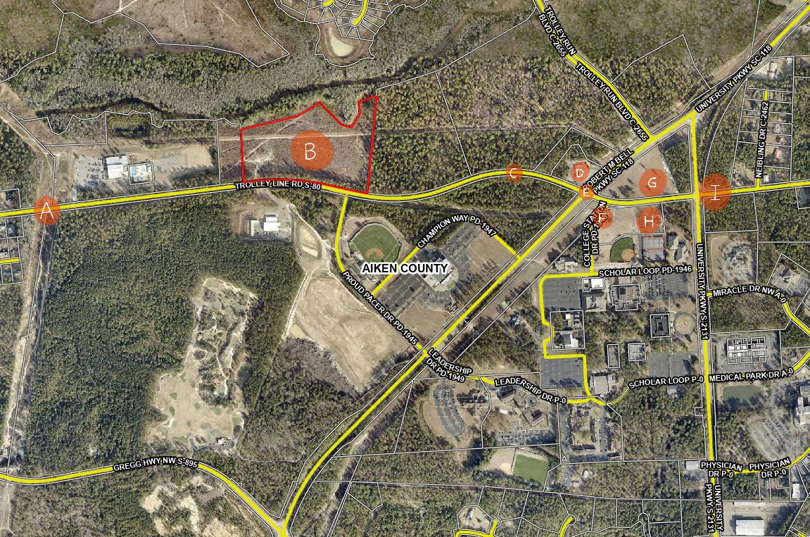
The Gregg Park neighborhood. Click to view full size.
The issues between SC Hwy 118 and Trolley Line Road are threefold. First, there is the increased traffic. Second, there is the lack of infrastructure to safely accommodate the increased traffic. Third are the erosion issues that have been created by clearing forests and leaving stormwater to do what it will. I will address these issues one at a time.
INCREASED TRAFFIC
The expanding Trolley Run Station subdivision has brought, and continues to bring, more residents to this area. Many of these residents use Trolley Line Rd as a shortcut/speedway to connect to the Aiken-Augusta/Jefferson Davis Hwy, or as a route to access the I-20 interstate or to access local schools, as this entire neighborhood, formerly zoned for Area 1, was rezoned for Area 3 schools in 2019.
The upcoming expansion of 45 houses, (see marker B on map below) which will be sandwiched in the now-treeless acreage between Bridge Creek and Trolley Line Rd will send yet more traffic onto Trolley Line Rd.
Click image to view full size
Shortly to the east on on Trolley Line Road, next to USCA, are the Advanced Manufacturing Collaborative facility, (see marker H on map), which is currently under construction, and the adjacent, soon-to-be-constructed National Guard Cybersecurity Readiness Center and Dreamport (see marker G on map). Will these workers use the Trolley Line Rd shortcut to travel back and forth to 1-20, North Augusta, Augusta, Fort Eisenhower and SRS?
At present, drivers traveling west on Trolley Line, toward Graniteville, encounter a speed zone change from 45 to 35 mph as they enter the older, established Gregg Park neighborhood (see marker A on map). These signs are ignored, and with impunity, as there is no traffic-law enforcement. The heavy demand of hurried drivers has transformed this road into a high-speed thoroughfare. This was already a special problem area, with many neighbors posting signs imploring drivers, to no avail, to observe the posted speed limit.
The problem has grown exponentially worse over just the past few years. Drivers routinely exceed the speed at 50-70 mph, race up behind slower drivers, then cruise into the other lane, disregarding the double-yellow line and without regard for oncoming or incoming traffic. This has created dangerous conditions for the five streets and the 70-something driveways to the Gregg Park neighborhood homes (see top map) that front this stretch of Trolley Line Road.
Drivers entering Trolley Line from a street or driveway can get caught unaware by a driver speeding down the road at 70 mph who’s just decided to pass someone, threatening a head-on collision. Drivers attempting to make a turn off Trolley Line into a driveway or street can likewise be caught unaware of a kamikaze driver from behind, about to T-bone them in an attempt to pass. Averting rear-end and head-on collisions is a daily fact of life. This stretch of road has all the ingredients for a deadly crash.
Our teenage daughters drive this road daily to and from school and work. In the absence of traffic enforcement — and with laws prohibiting cameras to catch people who drive dangerously and in gross excess of posted limits — I wonder how we will regain safe access to the roads that lead to our home?
INFRASTRUCTURE
The infrastructure in this area has not grown to accommodate the volume of the increased traffic. The traffic-light intersection of Robert M. Bell Pkwy and Trolley Line Rd (see marker E on map) is especially hazardous for its non-existent rules.. Since there are no turn lanes, motorists are compelled to make their own rules, which results in games of chicken as no one can tell if the person opposing them is going straight or turning. Often, left turners just sit there stumped through the green light as to what they are supposed to do: who goes first?
Meanwhile traffic continues to back up to the east, as USCA students struggle to make the left turn onto Trolley Line Rd. from College Station Dr. (see marker F on map) — an intersection that would benefit from prohibiting left turns during posted hours — say, from 3:00-6:00 pm? After all, USCA has other exits into less trafficked areas on University Pkwy that would not add to rush hour congestion. As it stands now, the traffic at the light backs up during rush hour, with cars lined up from the light at Robert M. Bell Pky to University Parkway (see marker I on map). Heading east on Robert M. Bell Pky at rush hour, traffic may back up all the way to Proud Pacer Dr (at the Convocation Center). This makes a nightmare of our drive home. This intersection is dysfunctional and dangerous from every direction.
EROSION
The above issues are compounded by the further lack of planning for stormwater runoff. As the entire area continues to be clear cut tract-by-tract for development, little regard is being paid to how this concrete jungle will affect the low-lying sandy areas. Already you can see the effects, as vigorous rainstorms create extreme runoff that creates a stream of water and loose sand across Trolley Line Rd. (see marker C on map). The river of runoff sand is visible alongside the road in this area.
This runoff is also causing hazards at the entrance to the Circle K (see marker D on map) at the corner of Robert M Bell and Trolley Line Rd., where sinkholes deep enough to break an axle continually emerge, then get repaired, then re-emerge. Drivers turning into Circle K from Trolley Line are sometimes forced to come to a complete stop, which creates a bottleneck at this spot as they try to ease their way around these holes to avoid damaging their cars.
How much more runoff-absorbing plant-life will be removed? Seeing the lack of planning in the lands east of the Gregg Park neighborhood the 118 bypass and Trolley Line Rd , our family lives in fear of potential development in the wooded hillside between the Gregg Park neighborhood and Gregg Hwy (see map at top). Were similar deforestation to take place in this area, the runoff to Laurel Drive and the Gregg Park neighborhood would be catastrophic. We’ve already reaped a sneak preview of that from minor tree removal up in that hillside.
Larger overview of this area
In the 10 years we’ve lived in the Gregg Park the quality of life has markedly diminished as we’ve watched the woodlands around our neighborhood disappear. One by one, swaths of old-growth, longleaf habitat have been destroyed and paved over with expanding residental development, a golf course, and expansions to the USCA complex. The felling of trees has been followed by the burning of huge piles of refuse wood, leaving the air choked with thick smoke for weeks at a time. Future growth should take into account both soil erosion and air quality when making decision about clearing forests.
All of this is to say that future growth in this area does not take place in a vacuum up on SC Hwy 118. The surrounding roads and neighborhoods are a part of the equation and should be taken into account.
My hope is that, by shedding some light on the issues that have arisen in the development along the Robert M. Bell Parkway and Trolley Line Rd, measures will be taken to mitigate some of these issues and to not repeat these mistakes in future development in this area.
To reiterate:
There need to be turning lanes in on both sides of Trolley Line Rd at the Robert M Bell Pkwy.
The erosion and runoff at the Circle K and further down Trolley Line (see map point C) need to be addressed.
The speeding issues on Trolley Line Rd. need to be addressed, particularly in the Gregg Park neighborhood area where speed-limit signs are ignored and no-passing lines are disregarded. With the numerous driveways and streets entering the roadway, the recipe has been written for deadly accidents.
Earlier this week, there occurred an odd and interesting two days for City of Aiken land use planning, involving a city planning commissioner publicly speaking out against the city’s planning process; followed the next day by the commission’s near-rejection of a high-density housing development north of the City limits.
The 4-3 vote to forward a 338-unit housing development proposal to City Council for its consideration followed a confusing public hearing—confusion over what was promised and demanded by the Commission of the developer, and what was delivered to the people who requested concept plan changes. Specifically, a required traffic study has yet to be submitted to the South Carolina Department of Transportation (SCDOT), City Fire Marshall, or City Engineer for their review and approval. Adding to the confusion, the developer answered an expressed, though informal, request for reduced housing density by adding more homes to the proposed subdivision.
(Update, Feburary 16, 2024. On January 31, 2024, the City of Aiken issued a Request for a Statement of Qualifications “to solicit input from interested firms to determine if they have the experience and qualifications necessary to assist the City” in replacing the existing 25-year Zoning Ordinance).
By Don Moniak
February 16, 2024
One day after a City of Aiken Planning Commission member was granted, as a private citizen, a half-hour forum before City Council to express his discontent with the city’s land planning system and zoning laws, the Planning Commission (1) nearly rejected a proposed 338-unit, high-density housing development on forested lands currently located outside the city limits and surrounded by distinctly different, long-established neighborhoods.
The development in question has no proposed neighborhood name to date; i.e “Henderson Downs” or “Aiken Village.” It is only referred to as the “May Royal Drive development.”
The development area is situated on four separately owned parcels across ~81 acres, north of the City limits and bounded by the 70-year- old Crosland Park neighborhood, Osbon Drive, May Royal Drive, and U.S. Highway 1 North. (Figure 1)
Figure 1. Affected area. The planned subdivision is on the undeveloped lands in the center of the photo (Aiken County Public.Net land database). Click to enlarge.
The First Public Hearing
On November 14, 2023, a Planning Commission public hearing was held to review, discuss, and accept citizen comments for the proposed, yet-to-be-named neighborhood. During that meeting, not a single area resident spoke in favor of the project. More than a dozen spoke in opposition to some or all parts of the plans and raised serious questions about public safety, traffic, stormwater impacts, property values, and general quality of life issues such as noise and light pollution.
Concerns and questions were mostly expressed by long-time county residents and taxpayers who have resided on significantly larger, quiet, generally wooded, properties along Osbon Drive and May Royal Drive. Both areas are outside of the city limits. The development is going to negatively impact their quality of life and property values, although in ways that are too expensive and difficult to measure and monitor.
Traffic and housing density emerged as two of the dominant issues (2) that ultimately led the Commission to table the proposal. However, the development application was tabled strictly due to traffic issues, whereas only a general desire for a reduction in housing density was expressed by commissioners.
In terms of housing density, the consensus was clear that seven homes per acre was inconsistent with the surrounding neighborhoods, which currently ranges from 1-4 homes per acre. That consensus was best summarized by Commissioner Jason Rabun’s statement that “the concept plan is expected to change drastically.” However, no housing density conditions were added to the application that were binding on the developer.
In terms of traffic, there were serious questions about access onto Highway 1 North, entrances along narrow, winding Osbon Drive (Figure 3), and increased traffic volume on May Royal Drive.
The Commission did make one binding decision pertaining to traffic. A motion was approved to table the developer’s application until after a traffic study was submitted; after which the review process would return to the Planning Commission before being forwarded to City Council.
The process for the Motion to Table was riddled with confusion. The official motion within the meeting minutes only stated that the application would be tabled until a traffic study has been completed and has received input from the City Engineer and Fire Marshal. The preceding minutes suggest the intent was for DOT approval (Figure 2).
Figure 2: Draft meeting minutes for the 11/14/23 Public Hearing. The minutes were approved in December 2023. Minutes are the official written record that city attorneys would present to a court in the case of civil litigation. Click to enlarge.
The transcript (3) from the City’s archived live-stream only adds to the confusion. During the discussion, Commissioners expressed a desire for the following variety of review and approval conditions:
“Approved by DOT and reviewed by the city Fire Marshall for their input.”
“Review by the City Engineer.”
“Meet with the Fire Marshall.”
“Proper weigh-in from the City Engineer and the local authority.”
Not a single one of these specific sentiments was enshrined in the official motion, as defined in the Meeting Minutes. However, the last condition, “proper weigh-in from the City Engineer and the local authority,” appears to have preceded the actual motion, but was not listed in the official record. Input was not required from SC DOT and no approvals were necessary from DOT or other parties; only input.
Figure 3. Osbon Drive is a winding, narrow line lacking any center line. The traffic study lists it as having a capacity of 11,000 vehicle trips per day.
The Second Public Hearing.
Neither the desire for lower housing density, nor the demand for a reviewed and/or approved traffic impact study, were satisfied in the developer’s amended application:
The updated concept plan not only failed to reduce the housing density, the developer added five more units to the plan, raising the number of homes from 333 to 338.
No detailed, final traffic impact study was contained in the Commission’s document package. Instead, only a two-page summary of an undisclosed, initial traffic study, from the City’s Charleston-based traffic engineering consultant, was provided. That summary includes the information that DOT approval would be necessary at a later date. (Figure 4)
During the public comment period, a few concerned citizens identified the discrepancies.
In terms of the traffic study, Mayfield Drive resident Jennifer Roberts asked some pointed questions at the 24:40 mark of the meeting:
Ms. Roberts: “At the previous meeting it seemed that it was indicated that the South Carolina DOT traffic study would be done prior to this meeting. I am kind of confused by that. I do understand there’s a process after everyone else’s comments but just want to note that we are very opposed to it.” It was also brought up that they would also need Fire Marshall approval. Has there been (approval)?”
City Planning Director Marya Moultrie: As far as the concept plan, (the Fire Marshall) will do an initial analysis of the roadways. But ultimately when the developer goes to submit a civil plan (the Fire Marshall) will make sure they have enough fire hydrants and their turn radiuses are appropriate. It’s actually typically done at a later date and although they do kind do a cursory look at this they won’t truly dive into it until a little bit later in the process but they do absolutely have to approve the roadways, their turnarounds, their hydrant locations, all that must be approved.
Ms. Roberts: As neighbors will we be notified of any of these approvals?
Ms. Moultrie: That’s all part of the internal review that goes through all the different departments including our Fire Marshall and Public Safety.
After explaining that City Council consideration of the development would be in two weeks, Ms. Moultrie stated further that, the developer does “not have to share their engineer review from the Fire Marshall” during City Council’s review process.
In other words, what was perceived as promises were not delivered, and neighbors will not even be entitled to scrutinize the final review process until well after the development’s concept plan is approved by City Council.
Thus, due to the unclear, and improperly transcribed requirements for the traffic study on November 14th, what was conveyed as a requirement three months ago was not provided prior to Tuesday night’s meeting. The developer was allowed to submit a traffic study that was only summarized by the city’s contract traffic consultant, who somehow concluded that the impacts of thousands of new vehicle trips on nearby roads would be minimal.
The traffic study itself is unavailable, and yet to be formally reviewed or approved by most of the parties identified during the November 14th hearing; unlike some other development proposals—such as Parker’s Kitchen on Whiskey Road—where SC DOT approval was required before the proposal was forwarded to City Council. Instead, only a summary of a study was provided, and that initial, undisclosed study does not appear to have been “detailed.” (Figure 4)
Figure 4. Summary of the Traffic Study. Although the increase in “average daily trips” is three times the existing traffic on May Royal Drive, where most new residents will enter their neighborhood, the conclusion was “minimal impact on the adjacent road system.” Click to enlarge.
In terms of the housing density, Osbon Drive resident Gloria Brown inquired as to how more units could be added after the Commission had expected a “drastic change” to the plan.
Commissioners tended to agree with the sentiment, perhaps best summarized by Chairman Ryan Reynold’s statement that, “it leaves a bad taste when the Commission asks for fewer homes and you come back with more.”
Commissioner Clarkson cast one of three opposing votes. the fourth time since September he has objected to a high-density residential development. Mr. Clarkson also, for at least the third time in 18 months, expressed a desire for more restrictive “overlay districts” to prevent the creation of “more Whiskey Roads.”
Commissioner Charles Matthews also cast an opposing vote, based largely on the failure to look at the big traffic picture along Highway 1 North (Figure 5), citing another large housing development under construction just a mile to the south.
Commissioner Peter Messina was the third opposing vote. He took most exception to the housing density, outlining how hundreds of 0.14 acre lots are not consistent with surrounding 0.25 to 1.5 acre parcels, which violates the guidelines for Planned Residential zoning district.
Figure 5. Columbia Highway/Hwy 1 North during a slow time of day. The white truck is at the junction of May Royal Drive. The 338-unit subdivision will be situated on ~80 acres behind that truck. Area residents raised numerous concerns about their inability to turn left during peak hours; and when Grace kaolinite trucks are busy and during Emerson Plant shift changes. Several people have expressed the need for a traffic signal.
The “Joint” City Council/Planning Commission Work Session
(Update. The audio recording of the 2/12/2024 Work Session is available here.)
Commissioner Messina’s concerns were highly consistent with statements he made to City Council the day before the public hearing. He was the center of attention during City Council’s February 12, 2024, work session; in which the only agenda item was titled, “Planning Commission Update.”
The staff memorandum for the work session stated:
”Councilwoman Gregory requested that Planning Commissioner Pete Messina and other members of the Planning Commission discuss current Planning Commission procedures with City Council to provide an update and feedback.
Commissioner Messina and other members of the Planning Commission will be present to speak to Council this evening. We would like to schedule a joint work session of City Council and Planning Commission at a mutually agreed upon date.”
However, only Mr. Messina was allowed to speak at length before Council. After presenting himself as “a citizen of the town,” (4) and not as a Planning Commissioner, he began by stating:
“My main concern this evening is to talk about proper planning and planning in the right places, not haphazard planning.”
The issues he identified, which strongly reflect sentiments shared by many people across the community; but that are seldom clearly conveyed during the approval process for developments, included:
“There is too much haphazard development and growth,” and it is “too piecemeal.”
“In the town we worked in, we asked for a buildout analysis, look at the potential of the property, then hire a traffic study for the whole town, not piecemeal. Four proposals in a row with 90 (daily vehicle trips) per day does not require a traffic study but in total they should.”
Stormwater management only manages excess stormwater coming off the site, but too many retention ponds releasing at the same time can still cause problems.
Planned residential zones of five acres are too small, and allowable housing densities are often too high on areas that are smaller. There should be zoning for everything from 1/2 to 5 acres.
In terms of impervious surfaces, there are no standards. The only impermeable surface requirement is that 20-25 percent is open space.
There is a lack of information for concept plan reviews. Sometimes facades are not available to council; for example the Silver bluff shopping center. “Too many plans are on an 8.5 x 11 piece of paper that require a magnifying glass.”
If something is allowed that does not make sense, then the zoning would change; i.e change a zoning code so a car wash would be zoned out.
“Giving us something nice” leads to other nice buildings. If you start with a car wash the next-door development is not going to be nice. It is not something to be proud of.
The Comprehensive Plan covers growth from 30K to 50K. “You have to know how large a town you want to be. Ask the question: do we need another Citizens Park, another Odell Weeks,” to accomodate growth?
The county donut holes are a problem throughout the city.
Mr. Messina was allowed 30 minutes to speak as a private citizen, more than ten times longer than other private citizens are allowed to speak during regular Council meetings on nonagenda issues; six times longer than citizens are allowed to speak during public hearings.
During his speech to Council, the other six Planning Commissioner’s watched and listened.
After Mr. Messina was finished, Commissioner Clayton Clarkson walked to the podium and stated that, “We are 35 minutes into a meeting and only one commissioner has spoken.”(4)
Other Council members expressed discomfort with the way the work session was handled. Councilwoman Kay Brohl, who has also served on the Planning Commission, asked whether these issues had been discussed among the Commission. Councilman Ed Woltz, who once chaired the Commission, stated that it was the first work session he had attended in which Council had no materials to prepare for the meeting (6).
Two weeks ago, on January 31, 2024, the City of Aiken issued a Request for a Statement of Qualifications “to solicit input from interested firms to determine if they have the experience and qualifications necessary to assist the City” in crafting a new Zoning Ordinance. The RFQ was issued because the City is “considering a near-future Request for Proposal (RFP) for a new City of Aiken Zoning Ordinance to replace the current 25-year-old City of Aiken Zoning Ordinance.
|City Council has the option of ordering non-decisional Public Hearings on any significant issue (7). Council could request public hearings—one for each section of town—during which all affected citizens, both city and county residents, could raise concerns and ask questions about the land planning process, the existing zoning ordinance, and any future zoning ordinance—just as Council allowed one private citizen thirty minutes to do so. If such hearings were held, some Planning Commissioners like Peter Messina would find that there is widespread support for their advocacy of stricter growth standards.
Figure 6. Citizen concerns being raised during most recent City of Aiken Planning Commission meeting. From left to right: Commissioners Peter Messina, Charles Matthews, Steve Simmons, Chairman Ryan Reynolds, Planning Director Marya Moultrie, Vice-Chairman Jason Rabun, and Commissioners Sam Erb and Clayton Clarkson.
Footnotes
(1) The Planning Commission is an appointed body that makes recommendations to City Council; which is responsible for approving ordinances allowing for developments to occur. It does, however, establish its own by-laws.
(2) Stormwater was another serious concern, and one facing further scrutiny.
The developer agreed to mitigate light, noise, and aesthetic impacts by constructing a fence around the entire subdivision, and leave a 25-foot wooded buffer between the fence and neighboring properties.
(3) The transcript from the archived live-stream, edited for clarity (double wording and pauses removed), and focused only on the traffic impact study requirements, is as follows:
At 1:07:30
Commission Chairman: The (first) motion was to accept the application with the listed recommendations. My recommendation is to amend the motion, you would have to amend the motion to:
Commissioner: Yes, to require that the traffic impact study come back before us with the required changes that are going to be implemented based on the egress and ingress out of the development plus the buffer changes.”
Chair: Okay just just for clarity did you want to have the traffic study completed prior to going to city council?
Commissioner: That’s what I was asking.
Chair: So Commissioner Clarkson is amending his motion to include Commissioner Rabun’s condition that to include, so we can get it correct, that traffic study be submitted and approved by DOT and reviewed by the city Fire Marshall for their their input. (emphasis added)
(Commissioners agree)
At 1:10:49:
Chair: I think to make it cleaner (and not send to City Council), you table the applications and wait for the proper traffic study with review from the city engineer and then that allows them to come back without scrapping their application, is that correct? So with that knowledge now you can make another amendment?
Commissioner: I would add to my motion which is saying that we add the conditions that we have all talked about but just move to table it to allow them time to do the traffic study to meet with the fire marshal to make sure that doesn’t change this development drastically.
Chair: The motion was originally to accept this for or approve it or recommend for city council for approval based on the conditions, Commissioner Clarkson has amended. his motion now to table both these applications until further traffic study, with proper weigh-in from the city engineer and the local Authority so we can have a better understanding of the traffic situation because that appears to be one of the biggest issues in this area that we all agree upon. With that being said, do I have a Second to table?
The motion then passed.
(4) Planning Commissioner Peter Messina was the Town Engineer and Planner for Bernard Township, New Jersey for more than three decades. The Township is located 40 miles and 55 minutes west of Manhattan, New York.
According the U.S. Census Bureau, the township has a current population of nearly 28,000; a medium household income of $174,072; a poverty rate of 3.2 percent; a combined white and Asian-American population of 93 percent; and a median housing value of $744,000.
(5) Mr. Clarkson also disputed an assertion made by Councilwoman Gregory’s at the onset of the meeting, that the planning department had not properly notified other commissioners of the meeting.
(6) The situation also contrasted sharply with the January 22, 2024, Council Meeting. During that meeting, a Recreation Commission member rose during the “public comments on nonagenda items” portion of the meeting to relay that Commission’s vote to recommend a pause in the Smith-Hazel City Park redevelopment effort until there was a public hearing on what was actually being proposed. He was abruptly interrupted and cut off after speaking past the allotted three minutes.
(7) Sec. 2-69 of City Code allows for “Hearings by special committees. The city council may appoint a special committee to assist in or hold a public hearing for the council at any time upon any matter pending before it. Minutes or reports of hearings held by special committees shall be filed with the city clerk as public records.”
Instead of this option, “work sessions,” which are not defined in City Code nor described in the City’s outdated Handbook for Effective Boards, Commissions, and Committees, are routinely held; during which citizens are spectators who are denied input.