
A public drop-in style meeting is scheduled for Monday, April 22 between 5:00-7:00 p.m. at the USCA Convocation Center to gather public comment and provide information to the public on an ongoing study to identify solutions to issues of traffic congestion, traffic safety, and projected growth along the 1.6-mile section of the Robert M. Bell Parkway/SC Highway 118 from USCA to Vaucluse Road. The public has been invited to email comments to Aiken County Planning and Development or to place comments in the comment box at the meeting. The letter below is being published here to raise awareness of this meeting and the issues that compel it. See more details on the meeting at bottom of this letter.
To Aiken County Planning and Development:
We moved to the Gregg Park neighborhood off Trolley Line Road in 2014. The close proximity to amenities like shopping, USCA, the YMCA and nearby Gregg Park Civic Center drew us to the area. We especially loved the relative quiet of the neighborhood and the setting — surrounded by pine woodlands and a couple miles removed from the bustle of traffic. This has changed a lot in the past 10 years, but most profoundly in the past several years, due in great part to a mix of unplanned and poorly planned growth in this area.
The collateral effects from this growth — issues of traffic congestion, traffic safety and erosion — have been driven down Trolley Line Road.

The issues between SC Hwy 118 and Trolley Line Road are threefold. First, there is the increased traffic. Second, there is the lack of infrastructure to safely accommodate the increased traffic. Third are the erosion issues that have been created by clearing forests and leaving stormwater to do what it will. I will address these issues one at a time.
INCREASED TRAFFIC
The expanding Trolley Run Station subdivision has brought, and continues to bring, more residents to this area. Many of these residents use Trolley Line Rd as a shortcut/speedway to connect to the Aiken-Augusta/Jefferson Davis Hwy, or as a route to access the I-20 interstate or to access local schools, as this entire neighborhood, formerly zoned for Area 1, was rezoned for Area 3 schools in 2019.
The upcoming expansion of 45 houses, (see marker B on map below) which will be sandwiched in the now-treeless acreage between Bridge Creek and Trolley Line Rd will send yet more traffic onto Trolley Line Rd.
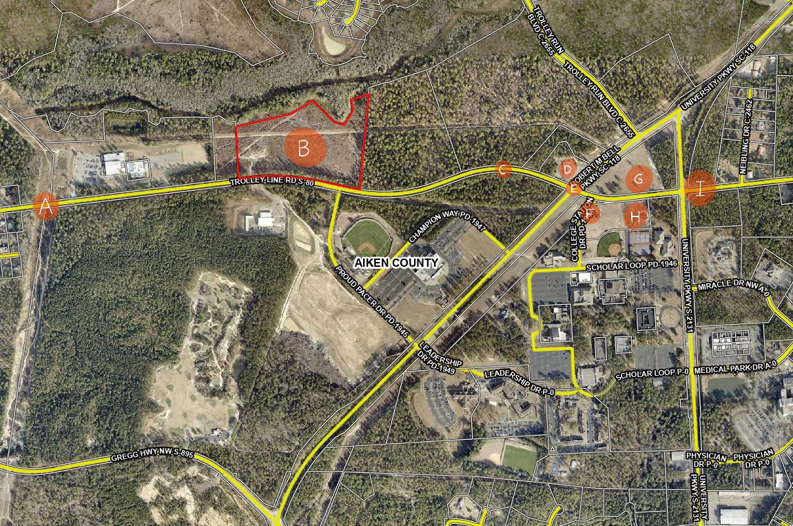
Shortly to the east on on Trolley Line Road, next to USCA, are the Advanced Manufacturing Collaborative facility, (see marker H on map), which is currently under construction, and the adjacent, soon-to-be-constructed National Guard Cybersecurity Readiness Center and Dreamport (see marker G on map). Will these workers use the Trolley Line Rd shortcut to travel back and forth to 1-20, North Augusta, Augusta, Fort Eisenhower and SRS?
At present, drivers traveling west on Trolley Line, toward Graniteville, encounter a speed zone change from 45 to 35 mph as they enter the older, established Gregg Park neighborhood (see marker A on map). These signs are ignored, and with impunity, as there is no traffic-law enforcement. The heavy demand of hurried drivers has transformed this road into a high-speed thoroughfare. This was already a special problem area, with many neighbors posting signs imploring drivers, to no avail, to observe the posted speed limit.
The problem has grown exponentially worse over just the past few years. Drivers routinely exceed the speed at 50-70 mph, race up behind slower drivers, then cruise into the other lane, disregarding the double-yellow line and without regard for oncoming or incoming traffic. This has created dangerous conditions for the five streets and the 70-something driveways to the Gregg Park neighborhood homes (see top map) that front this stretch of Trolley Line Road.
Drivers entering Trolley Line from a street or driveway can get caught unaware by a driver speeding down the road at 70 mph who’s just decided to pass someone, threatening a head-on collision. Drivers attempting to make a turn off Trolley Line into a driveway or street can likewise be caught unaware of a kamikaze driver from behind, about to T-bone them in an attempt to pass. Averting rear-end and head-on collisions is a daily fact of life. This stretch of road has all the ingredients for a deadly crash.
Our teenage daughters drive this road daily to and from school and work. In the absence of traffic enforcement — and with laws prohibiting cameras to catch people who drive dangerously and in gross excess of posted limits — I wonder how we will regain safe access to the roads that lead to our home?
INFRASTRUCTURE
The infrastructure in this area has not grown to accommodate the volume of the increased traffic. The traffic-light intersection of Robert M. Bell Pkwy and Trolley Line Rd (see marker E on map) is especially hazardous for its non-existent rules.. Since there are no turn lanes, motorists are compelled to make their own rules, which results in games of chicken as no one can tell if the person opposing them is going straight or turning. Often, left turners just sit there stumped through the green light as to what they are supposed to do: who goes first?
Meanwhile traffic continues to back up to the east, as USCA students struggle to make the left turn onto Trolley Line Rd. from College Station Dr. (see marker F on map) — an intersection that would benefit from prohibiting left turns during posted hours — say, from 3:00-6:00 pm? After all, USCA has other exits into less trafficked areas on University Pkwy that would not add to rush hour congestion. As it stands now, the traffic at the light backs up during rush hour, with cars lined up from the light at Robert M. Bell Pky to University Parkway (see marker I on map). Heading east on Robert M. Bell Pky at rush hour, traffic may back up all the way to Proud Pacer Dr (at the Convocation Center). This makes a nightmare of our drive home. This intersection is dysfunctional and dangerous from every direction.
EROSION
The above issues are compounded by the further lack of planning for stormwater runoff. As the entire area continues to be clear cut tract-by-tract for development, little regard is being paid to how this concrete jungle will affect the low-lying sandy areas. Already you can see the effects, as vigorous rainstorms create extreme runoff that creates a stream of water and loose sand across Trolley Line Rd. (see marker C on map). The river of runoff sand is visible alongside the road in this area.
This runoff is also causing hazards at the entrance to the Circle K (see marker D on map) at the corner of Robert M Bell and Trolley Line Rd., where sinkholes deep enough to break an axle continually emerge, then get repaired, then re-emerge. Drivers turning into Circle K from Trolley Line are sometimes forced to come to a complete stop, which creates a bottleneck at this spot as they try to ease their way around these holes to avoid damaging their cars.
How much more runoff-absorbing plant-life will be removed? Seeing the lack of planning in the lands east of the Gregg Park neighborhood the 118 bypass and Trolley Line Rd , our family lives in fear of potential development in the wooded hillside between the Gregg Park neighborhood and Gregg Hwy (see map at top). Were similar deforestation to take place in this area, the runoff to Laurel Drive and the Gregg Park neighborhood would be catastrophic. We’ve already reaped a sneak preview of that from minor tree removal up in that hillside.

In the 10 years we’ve lived in the Gregg Park the quality of life has markedly diminished as we’ve watched the woodlands around our neighborhood disappear. One by one, swaths of old-growth, longleaf habitat have been destroyed and paved over with expanding residental development, a golf course, and expansions to the USCA complex. The felling of trees has been followed by the burning of huge piles of refuse wood, leaving the air choked with thick smoke for weeks at a time. Future growth should take into account both soil erosion and air quality when making decision about clearing forests.
All of this is to say that future growth in this area does not take place in a vacuum up on SC Hwy 118. The surrounding roads and neighborhoods are a part of the equation and should be taken into account.
My hope is that, by shedding some light on the issues that have arisen in the development along the Robert M. Bell Parkway and Trolley Line Rd, measures will be taken to mitigate some of these issues and to not repeat these mistakes in future development in this area.
To reiterate:
- There need to be turning lanes in on both sides of Trolley Line Rd at the Robert M Bell Pkwy.
- The erosion and runoff at the Circle K and further down Trolley Line (see map point C) need to be addressed.
- The speeding issues on Trolley Line Rd. need to be addressed, particularly in the Gregg Park neighborhood area where speed-limit signs are ignored and no-passing lines are disregarded. With the numerous driveways and streets entering the roadway, the recipe has been written for deadly accidents.
Sincerely,
Wren Dexter
Graniteville, SC
________________________

Thank you for such a detailed, informative article.
Thanks, Ms. Dexter, for the well-reasoned and well-composed article. It reveals the severe inadequacies of “planning” on the part of local government agencies.
It also reprises a familiar tune. All manner of “development” — in the name of “progress” and “growth” — is sanctioned, permitted and encouraged by local governments without proper regard or consideration for the negative impacts on the people who reside in those areas — in many cases for decades. It really is quite a cold-hearted and myopic style of governance; that reveals some of the worst consequences of a “growth” at-all-costs attitude .
I know from my own occasional trips along Trolley Line Rd., in the vicinity of the YMCA and Gregg Park, that the governing authorities have allowed that stretch of roadway to devolve into an exceedingly dangerous state of affairs.
Finally, Mr. Moniak’s comments remind us of the craziness and inequity of Aiken County’s policies regarding taxation of “agricultural” property. Those policies shift the tax burden from owners of large tracts of valuable developable property, to business owners, home owners and occupants of rental properties (as passed to them by the owners through rental rates ).
The author clearly has a deep understanding of the area’s landscape and traffic patterns.
One note on Area B in the figures above, the clearcut area east of the YMCA which is under development for residential.
It is owned by Sage Mill Residential, LLC; which also owns most of the yet to be developed Trolley Run subdivision property.
This 19 acre property remains classed as agricultural in the County’s land database. Until 2023, it was part of a larger 700+ acre parcel (under)valued at $1.5 million by the County Assessor.
Then it was separated and the land value was a mere $4200, with an assessed value (upon which the tax bill is based) of only $170. The tax bill for 2023, after it was clearcut for residential and had zero agricultural/timber value, was a mere $39.87.
This points to the inadequacies of the existing system of property taxation in Aiken County. Developers get away with the ag classification and pay negligible tax even after their properties are approved for residential use. If these properties were taxed as commercial at an earlier stage, more revenues would be collected that could be applied to the infrastructure demands driven by residential and commercial growth.
As it is, those of us who are subjected to much higher tax rates are paying for the impacts created by developers and sanctioned by county officials.
That property in question, and there are many more like it, is at
https://qpublic.schneidercorp.com/Application.aspx?AppID=844&LayerID=15264&PageTypeID=4&PageID=6879&KeyValue=087-10-01-002
This problem is all over Aiken County. Lack of police presence and action is the biggest problem.
True enough. The problems are all over Aiken County. Lack of traffic safety enforcement is definitely part of it, along with lack of proper planning. The different here is that the County is doing a study on the mess that’s been created on SC Hwy 118/Robert M Bell Parkway near USCA. Hopefully some of the problems can be remedied and past mistakes not repeated in the future.